Pingxi geodata
Pingxi (Sichuan) is a seat of a fourth-order administrative division; located in China in Asia/Shanghai (GMT+8) time zone. In our database, there are 1268 cities with bigger population. Compared to other cities in China, 64.6% of cities are located further ↓South; 86.6% of cities are located further →East and 89.5% of cities have lower elevation than Pingxi. Note1


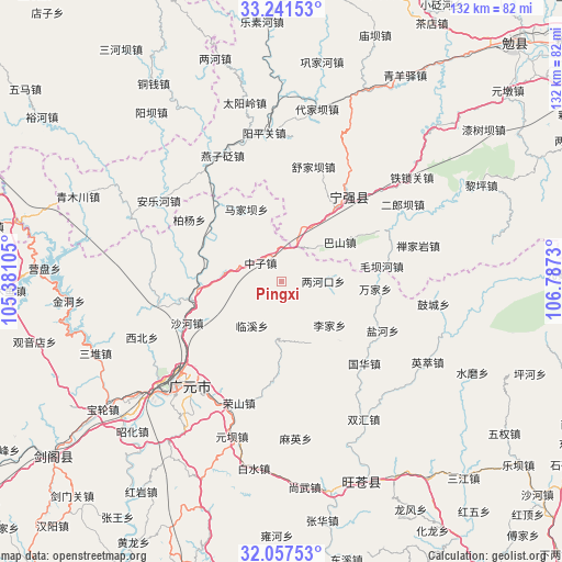
Pingxi GPS coordinates[2]
32° 39' 5.364" North, 106° 5' 3.012" East
| Map corner | latitude | longitude |
|---|---|---|
| Upper-left | 33.24153°, | 105.38105° |
| Center: | 32.65149°, | 106.08417° |
| Lower-right: | 32.05753°, | 106.7873° |
| Map W x H: | 131.6×131.6 km | = 81.8×81.8mi |
| max Lat: | 53.31946° ⇑35.4% North |
| Pingxi: | 32.65149° |
| min Lat: | ⇓64.6% South 18.22056° |
| min Long | Pingxi | max Long |
| 75.07348° | 106.08417° | 134.28917° |
| W 13.4%⇐ | ⇒86.6% E |
Elevation
Elevation of Pingxi is 1310 m = 4298 ft, and this is 825.2 m = 2707 ft above average elevation for this country.
| Max E: |
5622 m = 18445 ft | 10.5% |
| Pingxi | 1310 m 4298 ft | |
| Avg. | 484.8 m = 1591 ft | |
Min E: |
-3 m = -10 ft | 89.5% |
See also: China elevation on elevation.city.
Geographical zone
Pingxi is located in North temperate zone (between Tropic of Cancer and the Arctic Circle). Distance of this Northern Tropic circle is 1024.6 km =636.7 mi to South.| Distance of | km | miles | from Pingxi |
|---|---|---|---|
| North Pole | 6376.6 | 3962.2 | to North |
| Arctic Circle | 3770.7 | 2343 | to North |
| Tropic Cancer | 1024.6 | 636.7 | to South |
| Equator | 3630.5 | 2255.9 | to South |


Nearby cities:
15 places around Pingxi: (largest is in red/bold)
• Chaotian
18.7 km =11.6 mi,  267°
267°
• Guohua
27.3 km =17 mi,  134°
134°
• Hanyuan
25.6 km =15.9 mi,  37°
37°
• Huangbayi
12.2 km =7.6 mi,  19°
19°
• Lijia
15.2 km =9.4 mi, 131°
• Linxi
12.3 km =7.6 mi,  213°
213°
• Majiaba
18.5 km =11.5 mi,  334°
334°
• Maliu
14.4 km =8.9 mi,  194°
194°
• Qinglin
14.6 km =9.1 mi,  341°
341°
• Wangjia
15.6 km =9.7 mi,  154°
154°
• Yanhe
26.4 km =16.4 mi,  115°
115°
• Yanzibian
31.5 km =19.6 mi, 331°
• Zengjia
3.9 km =2.4 mi,  155°
155°
• Zhongzi
6.6 km =4.1 mi,  312°
312°
• Zhuandou
6.5 km =4 mi,  351°
351°
Sources, notices
• [Note1] Compared only with cities in China existing in our database
• [Src1] Map data: © OpenStreetMap contributors (CC-BY-SA)
• [Src2] Other city data from geonames.org with taken over terms of usage.
• [Src3] Geographical zone / Annual Mean Temperature by Robert A. Rohde @ Wikipedia
