Yanhe geodata
Yanhe (Sichuan) is a seat of a fourth-order administrative division; located in China in Asia/Shanghai (GMT+8) time zone. In our database, there are 1268 cities with bigger population. Compared to other cities in China, 64.2% of cities are located further ↓South; 85.7% of cities are located further →East and 83% of cities have lower elevation than Yanhe. Note1


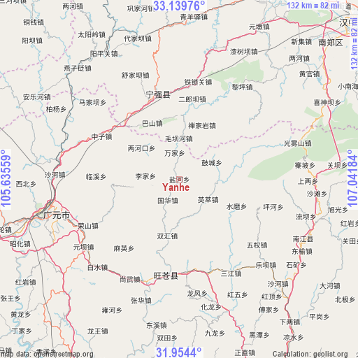
Yanhe GPS coordinates[2]
32° 32' 56.544" North, 106° 20' 19.356" East
| Map corner | latitude | longitude |
|---|---|---|
| Upper-left | 33.13976°, | 105.63559° |
| Center: | 32.54904°, | 106.33871° |
| Lower-right: | 31.9544°, | 107.04184° |
| Map W x H: | 131.8×131.8 km | = 81.9×81.9mi |
| max Lat: | 53.31946° ⇑35.8% North |
| Yanhe: | 32.54904° |
| min Lat: | ⇓64.2% South 18.22056° |
| min Long | Yanhe | max Long |
| 75.07348° | 106.33871° | 134.28917° |
| W 14.3%⇐ | ⇒85.7% E |
Elevation
Elevation of Yanhe is 850 m = 2789 ft, and this is 365.2 m = 1198 ft above average elevation for this country.
| Max E: |
5622 m = 18445 ft | 17% |
| Yanhe | 850 m 2789 ft | |
| Avg. | 484.8 m = 1591 ft | |
Min E: |
-3 m = -10 ft | 83% |
See also: China elevation on elevation.city.
Geographical zone
Yanhe is located in North temperate zone (between Tropic of Cancer and the Arctic Circle). Distance of this Northern Tropic circle is 1013.2 km =629.6 mi to South.| Distance of | km | miles | from Yanhe |
|---|---|---|---|
| North Pole | 6387.9 | 3969.3 | to North |
| Arctic Circle | 3782.1 | 2350.1 | to North |
| Tropic Cancer | 1013.2 | 629.6 | to South |
| Equator | 3619.1 | 2248.8 | to South |


Nearby cities:
15 places around Yanhe: (largest is in red/bold)
• Donghe
35.3 km =21.9 mi,  185°
185°
• Guohua
8.8 km =5.5 mi,  209°
209°
• Hanyuan
32.7 km =20.3 mi,  345°
345°
• Huangbayi
30.3 km =18.8 mi,  319°
319°
• Huangyang
34.6 km =21.5 mi,  175°
175°
• Lijia
12.5 km =7.8 mi,  275°
275°
• Linxi
30.7 km =19.1 mi,  272°
272°
• Maliu
27.5 km =17.1 mi,  264°
264°
• Maying
32.5 km =20.2 mi,  218°
218°
• Pingxi
26.4 km =16.4 mi,  295°
295°
• Wangjia
17.2 km =10.7 mi, 261°
• Yingcui
12.9 km =8 mi,  125°
125°
• Zengjia
23.6 km =14.7 mi,  289°
289°
• Zhongzi
32.8 km =20.4 mi, 298°
• Zhuandou
30.6 km =19 mi,  305°
305°
Sources, notices
• [Note1] Compared only with cities in China existing in our database
• [Src1] Map data: © OpenStreetMap contributors (CC-BY-SA)
• [Src2] Other city data from geonames.org with taken over terms of usage.
• [Src3] Geographical zone / Annual Mean Temperature by Robert A. Rohde @ Wikipedia
