Lingyuan geodata
Lingyuan (Zhejiang) is a seat of a fourth-order administrative division; located in China in Asia/Shanghai (GMT+8) time zone. In our database, there are 1268 cities with bigger population. Compared to other cities in China, 54.9% of cities are located further ↑North; 77.4% of cities are located further ←West and 50.7% of cities have lower elevation than Lingyuan. Note1


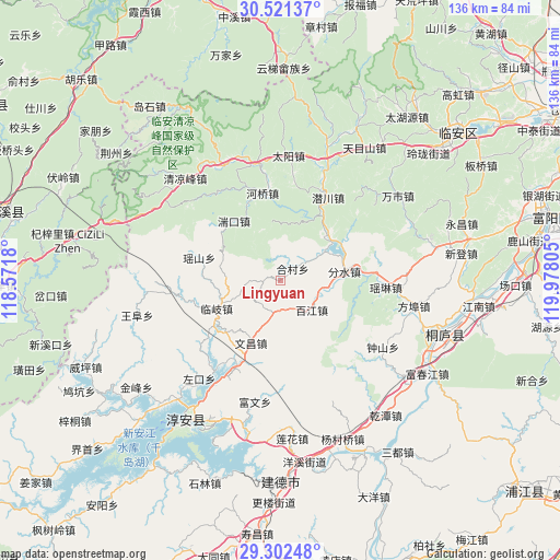
Lingyuan GPS coordinates[2]
29° 54' 49.644" North, 119° 16' 29.712" East
| Map corner | latitude | longitude |
|---|---|---|
| Upper-left | 30.52137°, | 118.5718° |
| Center: | 29.91379°, | 119.27492° |
| Lower-right: | 29.30248°, | 119.97805° |
| Map W x H: | 135.5×135.5 km | = 84.2×84.2mi |
| max Lat: | 53.31946° ⇑54.9% North |
| Lingyuan: | 29.91379° |
| min Lat: | ⇓45.1% South 18.22056° |
| min Long | Lingyuan | max Long |
| 75.07348° | 119.27492° | 134.28917° |
| W 77.4%⇐ | ⇒22.6% E |
Elevation
Elevation of Lingyuan is 171 m = 561 ft, and this is 313.8 m = 1030 ft below average elevation for this country.
| Max E: |
5622 m = 18445 ft | 49.3% |
| Avg. | 484.8 m = 1591 ft | |
| Lingyuan | 171 m = 561 ft | |
Min E: |
-3 m = -10 ft | 50.7% |
See also: China elevation on elevation.city.
Geographical zone
Lingyuan is located in North temperate zone (between Tropic of Cancer and the Arctic Circle). Distance of this Northern Tropic circle is 720.2 km =447.5 mi to South.| Distance of | km | miles | from Lingyuan |
|---|---|---|---|
| North Pole | 6681 | 4151.4 | to North |
| Arctic Circle | 4075.1 | 2532.1 | to North |
| Tropic Cancer | 720.2 | 447.5 | to South |
| Equator | 3326.1 | 2066.7 | to South |


Nearby cities:
15 places around Lingyuan: (largest is in red/bold)
• Baijiang
10.4 km =6.5 mi,  132°
132°
• Bipu
24.1 km =15 mi,  87°
87°
• Donghui
7.1 km =4.4 mi,  177°
177°
• Fenshui
15.1 km =9.4 mi,  82°
82°
• Hecun
4.2 km =2.6 mi,  48°
48°
• Heqiao
21.5 km =13.4 mi,  348°
348°
• Leping
15.9 km =9.9 mi, 47°
• Linqi
16.8 km =10.4 mi,  246°
246°
• Qianchuan
22.6 km =14 mi,  29°
29°
• Tuankou
18.5 km =11.5 mi,  320°
320°
• Wenchang
16.3 km =10.1 mi,  205°
205°
• Yaolin
25.5 km =15.8 mi, 93°
• Yaoshan
20.9 km =13 mi,  285°
285°
• Yihe
9.3 km =5.8 mi,  56°
56°
• Yinzhu
15.7 km =9.8 mi, 60°
Sources, notices
• [Note1] Compared only with cities in China existing in our database
• [Src1] Map data: © OpenStreetMap contributors (CC-BY-SA)
• [Src2] Other city data from geonames.org with taken over terms of usage.
• [Src3] Geographical zone / Annual Mean Temperature by Robert A. Rohde @ Wikipedia
