Linqi geodata
Linqi (Zhejiang) is a seat of a fourth-order administrative division; located in China in Asia/Shanghai (GMT+8) time zone. In our database, there are 1268 cities with bigger population. Compared to other cities in China, 55.7% of cities are located further ↑North; 76.6% of cities are located further ←West and 54.6% of cities have higher elevation than Linqi. Note1


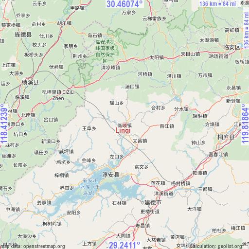
Linqi GPS coordinates[2]
29° 51' 10.008" North, 119° 6' 55.836" East
| Map corner | latitude | longitude |
|---|---|---|
| Upper-left | 30.46074°, | 118.41239° |
| Center: | 29.85278°, | 119.11551° |
| Lower-right: | 29.2411°, | 119.81864° |
| Map W x H: | 135.6×135.6 km | = 84.3×84.3mi |
| max Lat: | 53.31946° ⇑55.7% North |
| Linqi: | 29.85278° |
| min Lat: | ⇓44.3% South 18.22056° |
| min Long | Linqi | max Long |
| 75.07348° | 119.11551° | 134.28917° |
| W 76.6%⇐ | ⇒23.4% E |
Elevation
Elevation of Linqi is 134 m = 440 ft, and this is 350.8 m = 1151 ft below average elevation for this country.
| Max E: |
5622 m = 18445 ft | 54.6% |
| Avg. | 484.8 m = 1591 ft | |
| Linqi | 134 m = 440 ft | |
Min E: |
-3 m = -10 ft | 45.4% |
See also: China elevation on elevation.city.
Geographical zone
Linqi is located in North temperate zone (between Tropic of Cancer and the Arctic Circle). Distance of this Northern Tropic circle is 713.4 km =443.3 mi to South.| Distance of | km | miles | from Linqi |
|---|---|---|---|
| North Pole | 6687.7 | 4155.5 | to North |
| Arctic Circle | 4081.9 | 2536.4 | to North |
| Tropic Cancer | 713.4 | 443.3 | to South |
| Equator | 3319.3 | 2062.5 | to South |


Nearby cities:
15 places around Linqi: (largest is in red/bold)
• Baijiang
23.1 km =14.4 mi,  90°
90°
• Dashe
21 km =13 mi,  286°
286°
• Donghui
15.7 km =9.8 mi, 91°
• Hecun
20.8 km =12.9 mi,  62°
62°
• Lingyuan
16.8 km =10.4 mi,  66°
66°
• Songcun
25.1 km =15.6 mi,  235°
235°
• Tangban
27 km =16.8 mi,  225°
225°
• Tangcun
26.3 km =16.3 mi,  258°
258°
• Tuankou
21.3 km =13.2 mi,  9°
9°
• Wangfu
19.7 km =12.2 mi,  266°
266°
• Wangzhai
19.9 km =12.4 mi,  209°
209°
• Wenchang
11.4 km =7.1 mi,  133°
133°
• Yaoshan
13.3 km =8.3 mi,  339°
339°
• Yihe
26 km =16.2 mi, 62°
• Zuokou
15.1 km =9.4 mi, 206°
Sources, notices
• [Note1] Compared only with cities in China existing in our database
• [Src1] Map data: © OpenStreetMap contributors (CC-BY-SA)
• [Src2] Other city data from geonames.org with taken over terms of usage.
• [Src3] Geographical zone / Annual Mean Temperature by Robert A. Rohde @ Wikipedia
