Yaoshan geodata
Yaoshan (Zhejiang) is a seat of a fourth-order administrative division; located in China in Asia/Shanghai (GMT+8) time zone. In our database, there are 1268 cities with bigger population. Compared to other cities in China, 54.4% of cities are located further ↑North; 76.4% of cities are located further ←West and 52.9% of cities have lower elevation than Yaoshan. Note1


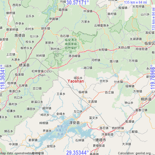
Yaoshan GPS coordinates[2]
29° 57' 51.984" North, 119° 3' 59.508" East
| Map corner | latitude | longitude |
|---|---|---|
| Upper-left | 30.57171°, | 118.36341° |
| Center: | 29.96444°, | 119.06653° |
| Lower-right: | 29.35344°, | 119.76966° |
| Map W x H: | 135.5×135.5 km | = 84.2×84.2mi |
| max Lat: | 53.31946° ⇑54.4% North |
| Yaoshan: | 29.96444° |
| min Lat: | ⇓45.6% South 18.22056° |
| min Long | Yaoshan | max Long |
| 75.07348° | 119.06653° | 134.28917° |
| W 76.4%⇐ | ⇒23.6% E |
Elevation
Elevation of Yaoshan is 188 m = 617 ft, and this is 296.8 m = 974 ft below average elevation for this country.
| Max E: |
5622 m = 18445 ft | 47.1% |
| Avg. | 484.8 m = 1591 ft | |
| Yaoshan | 188 m = 617 ft | |
Min E: |
-3 m = -10 ft | 52.9% |
See also: China elevation on elevation.city.
Geographical zone
Yaoshan is located in North temperate zone (between Tropic of Cancer and the Arctic Circle). Distance of this Northern Tropic circle is 725.8 km =451 mi to South.| Distance of | km | miles | from Yaoshan |
|---|---|---|---|
| North Pole | 6675.3 | 4147.8 | to North |
| Arctic Circle | 4069.4 | 2528.6 | to North |
| Tropic Cancer | 725.8 | 451 | to South |
| Equator | 3331.7 | 2070.2 | to South |


Nearby cities:
15 places around Yaoshan: (largest is in red/bold)
• Dashe
16.6 km =10.3 mi,  247°
247°
• Donghui
24.1 km =15 mi,  121°
121°
• Hecun
23.4 km =14.5 mi,  96°
96°
• Heqiao
22.1 km =13.7 mi,  45°
45°
• Jinchuan
21.3 km =13.2 mi,  274°
274°
• Lingyuan
20.9 km =13 mi,  105°
105°
• Linqi
13.3 km =8.3 mi,  159°
159°
• Longgang
22.7 km =14.1 mi,  13°
13°
• Maxiao
22.7 km =14.1 mi,  334°
334°
• Qingliangfeng
19.8 km =12.3 mi,  349°
349°
• Tuankou
12 km =7.5 mi,  43°
43°
• Wangfu
20.2 km =12.6 mi,  227°
227°
• Wenchang
24.1 km =15 mi,  147°
147°
• Zhupu
24 km =14.9 mi,  289°
289°
• Zuokou
26 km =16.2 mi,  184°
184°
Sources, notices
• [Note1] Compared only with cities in China existing in our database
• [Src1] Map data: © OpenStreetMap contributors (CC-BY-SA)
• [Src2] Other city data from geonames.org with taken over terms of usage.
• [Src3] Geographical zone / Annual Mean Temperature by Robert A. Rohde @ Wikipedia
