Zhoujia geodata
Zhoujia (Zhejiang) is a seat of a fourth-order administrative division; located in China in Asia/Shanghai (GMT+8) time zone. In our database, there are 1268 cities with bigger population. Compared to other cities in China, 64.6% of cities are located further ↑North; 75.5% of cities are located further ←West and 62.9% of cities have higher elevation than Zhoujia. Note1


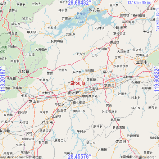
Zhoujia GPS coordinates[2]
29° 4' 19.632" North, 118° 54' 18.324" East
| Map corner | latitude | longitude |
|---|---|---|
| Upper-left | 29.68482°, | 118.20197° |
| Center: | 29.07212°, | 118.90509° |
| Lower-right: | 28.45576°, | 119.60822° |
| Map W x H: | 136.7×136.7 km | = 84.9×84.9mi |
| max Lat: | 53.31946° ⇑64.6% North |
| Zhoujia: | 29.07212° |
| min Lat: | ⇓35.4% South 18.22056° |
| min Long | Zhoujia | max Long |
| 75.07348° | 118.90509° | 134.28917° |
| W 75.5%⇐ | ⇒24.5% E |
Elevation
Elevation of Zhoujia is 83 m = 272 ft, and this is 401.8 m = 1318 ft below average elevation for this country.
| Max E: |
5622 m = 18445 ft | 62.9% |
| Avg. | 484.8 m = 1591 ft | |
| Zhoujia | 83 m = 272 ft | |
Min E: |
-3 m = -10 ft | 37.1% |
See also: China elevation on elevation.city.
Geographical zone
Zhoujia is located in North temperate zone (between Tropic of Cancer and the Arctic Circle). Distance of this Northern Tropic circle is 626.6 km =389.4 mi to South.| Distance of | km | miles | from Zhoujia |
|---|---|---|---|
| North Pole | 6774.5 | 4209.5 | to North |
| Arctic Circle | 4168.7 | 2590.3 | to North |
| Tropic Cancer | 626.6 | 389.4 | to South |
| Equator | 3232.5 | 2008.6 | to South |


Nearby cities:
15 places around Zhoujia: (largest is in red/bold)
• Baitashan
7.5 km =4.7 mi,  216°
216°
• Datou
16.9 km =10.5 mi,  302°
302°
• Duze
7 km =4.3 mi,  34°
34°
• Gaojia
14.3 km =8.9 mi,  122°
122°
• Hangbu
19.6 km =12.2 mi, 219°
• Huipinggeng
20.4 km =12.7 mi,  345°
345°
• Jiuhua
6.6 km =4.1 mi,  245°
245°
• Lianhua
10 km =6.2 mi,  89°
89°
• Quzhou
13 km =8.1 mi,  195°
195°
• Shiliang
13.2 km =8.2 mi,  244°
244°
• Shisanli
7.5 km =4.7 mi,  178°
178°
• Shuangqiao
7.2 km =4.5 mi,  343°
343°
• Xiacaoqiao
14 km =8.7 mi,  332°
332°
• Xiakou
11.3 km =7 mi,  44°
44°
• Yunxi
4.4 km =2.7 mi,  130°
130°
Sources, notices
• [Note1] Compared only with cities in China existing in our database
• [Src1] Map data: © OpenStreetMap contributors (CC-BY-SA)
• [Src2] Other city data from geonames.org with taken over terms of usage.
• [Src3] Geographical zone / Annual Mean Temperature by Robert A. Rohde @ Wikipedia
