Huipinggeng geodata
Huipinggeng (Zhejiang) is a seat of a fourth-order administrative division; located in China in Asia/Shanghai (GMT+8) time zone. In our database, there are 1268 cities with bigger population. Compared to other cities in China, 62.6% of cities are located further ↑North; 75.3% of cities are located further ←West and 78.1% of cities have lower elevation than Huipinggeng. Note1


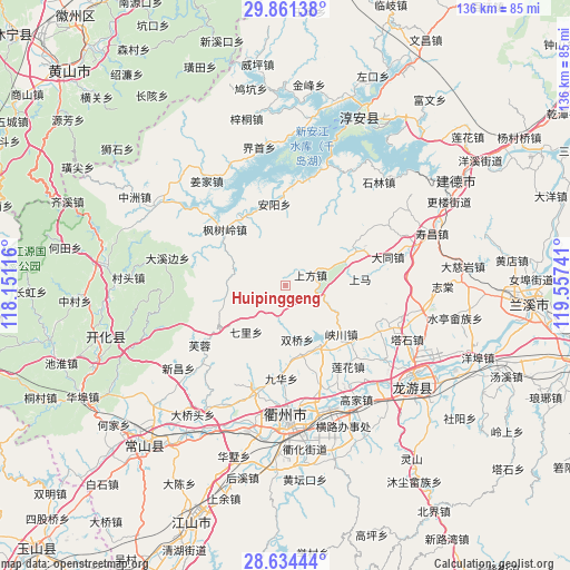
Huipinggeng GPS coordinates[2]
29° 14' 59.1" North, 118° 51' 15.408" East
| Map corner | latitude | longitude |
|---|---|---|
| Upper-left | 29.86138°, | 118.15116° |
| Center: | 29.24975°, | 118.85428° |
| Lower-right: | 28.63444°, | 119.55741° |
| Map W x H: | 136.4×136.4 km | = 84.8×84.8mi |
| max Lat: | 53.31946° ⇑62.6% North |
| Huipinggeng: | 29.24975° |
| min Lat: | ⇓37.4% South 18.22056° |
| min Long | Huipinggeng | max Long |
| 75.07348° | 118.85428° | 134.28917° |
| W 75.3%⇐ | ⇒24.7% E |
Elevation
Elevation of Huipinggeng is 618 m = 2028 ft, and this is 133.2 m = 437 ft above average elevation for this country.
| Max E: |
5622 m = 18445 ft | 21.9% |
| Huipinggeng | 618 m 2028 ft | |
| Avg. | 484.8 m = 1591 ft | |
Min E: |
-3 m = -10 ft | 78.1% |
See also: China elevation on elevation.city.
Geographical zone
Huipinggeng is located in North temperate zone (between Tropic of Cancer and the Arctic Circle). Distance of this Northern Tropic circle is 646.3 km =401.6 mi to South.| Distance of | km | miles | from Huipinggeng |
|---|---|---|---|
| North Pole | 6754.8 | 4197.2 | to North |
| Arctic Circle | 4148.9 | 2578 | to North |
| Tropic Cancer | 646.3 | 401.6 | to South |
| Equator | 3252.3 | 2020.9 | to South |


Nearby cities:
15 places around Huipinggeng: (largest is in red/bold)
• Anyang
19 km =11.8 mi,  352°
352°
• Baima
13.4 km =8.3 mi,  266°
266°
• Datou
14.3 km =8.9 mi,  221°
221°
• Dongshandi
24.3 km =15.1 mi,  235°
235°
• Duze
16.5 km =10.3 mi,  147°
147°
• Fengshuling
19.6 km =12.2 mi,  312°
312°
• Jiuhua
22.5 km =14 mi,  182°
182°
• Lianhua
24.7 km =15.3 mi,  142°
142°
• Shangfang
6.4 km =4 mi,  69°
69°
• Shangma
17.9 km =11.1 mi,  85°
85°
• Shuangqiao
13.2 km =8.2 mi,  167°
167°
• Xiacaoqiao
7.5 km =4.7 mi,  191°
191°
• Xiakou
17.4 km =10.8 mi,  132°
132°
• Yunxi
24.1 km =15 mi,  159°
159°
• Zhoujia
20.4 km =12.7 mi, 165°
Sources, notices
• [Note1] Compared only with cities in China existing in our database
• [Src1] Map data: © OpenStreetMap contributors (CC-BY-SA)
• [Src2] Other city data from geonames.org with taken over terms of usage.
• [Src3] Geographical zone / Annual Mean Temperature by Robert A. Rohde @ Wikipedia
