Luzhou geodata
Luzhou (Guangdong) is a seat of a fourth-order administrative division; located in China in Asia/Shanghai (GMT+8) time zone. In our database, there are 1268 cities with bigger population. Compared to other cities in China, 92.8% of cities are located further ↑North; 51.7% of cities are located further ←West and 80.8% of cities have higher elevation than Luzhou. Note1


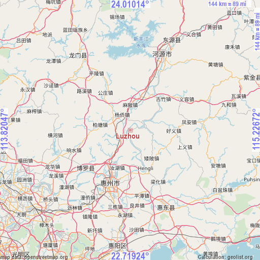
Luzhou GPS coordinates[2]
23° 21' 58.536" North, 114° 31' 24.924" East
| Map corner | latitude | longitude |
|---|---|---|
| Upper-left | 24.01014°, | 113.82047° |
| Center: | 23.36626°, | 114.52359° |
| Lower-right: | 22.71924°, | 115.22672° |
| Map W x H: | 143.5×143.5 km | = 89.2×89.2mi |
| max Lat: | 53.31946° ⇑92.8% North |
| Luzhou: | 23.36626° |
| min Lat: | ⇓7.2% South 18.22056° |
| min Long | Luzhou | max Long |
| 75.07348° | 114.52359° | 134.28917° |
| W 51.7%⇐ | ⇒48.3% E |
Elevation
Elevation of Luzhou is 25 m = 82 ft, and this is 459.8 m = 1509 ft below average elevation for this country.
| Max E: |
5622 m = 18445 ft | 80.8% |
| Avg. | 484.8 m = 1591 ft | |
| Luzhou | 25 m = 82 ft | |
Min E: |
-3 m = -10 ft | 19.2% |
See also: China elevation on elevation.city.
Geographical zone
Luzhou is located in North Torrid zone (between Equator and Tropic of Cancer). Distance of this Northern Tropic circle is 7.8 km =4.8 mi to North.| Distance of | km | miles | from Luzhou |
|---|---|---|---|
| North Pole | 7409 | 4603.7 | to North |
| Arctic Circle | 4803.1 | 2984.5 | to North |
| Tropic Cancer | 7.8 | 4.8 | to North |
| Equator | 2598.1 | 1614.4 | to South |


Nearby cities:
15 places around Luzhou: (largest is in red/bold)
• Aipi
19.3 km =12 mi,  142°
142°
• Baitang
16.9 km =10.5 mi,  280°
280°
• Dalan
21.7 km =13.5 mi,  115°
115°
• Gongzhuang
23.6 km =14.7 mi,  321°
321°
• Guanyinge
6.6 km =4.1 mi,  57°
57°
• Haoyi
23.6 km =14.7 mi,  88°
88°
• Hengli
23.8 km =14.8 mi,  155°
155°
• Mabei
14.1 km =8.8 mi,  359°
359°
• Ruhu
21.7 km =13.5 mi,  200°
200°
• Shiba
19.5 km =12.1 mi,  14°
14°
• Shuikou
23.6 km =14.7 mi,  180°
180°
• Taimei
7.3 km =4.5 mi,  229°
229°
• Xiaojinkou
22.7 km =14.1 mi,  216°
216°
• Yangcun
9.1 km =5.7 mi,  327°
327°
• Yangqiao
9.8 km =6.1 mi, 332°
Sources, notices
• [Note1] Compared only with cities in China existing in our database
• [Src1] Map data: © OpenStreetMap contributors (CC-BY-SA)
• [Src2] Other city data from geonames.org with taken over terms of usage.
• [Src3] Geographical zone / Annual Mean Temperature by Robert A. Rohde @ Wikipedia
