Xiaojinkou geodata
Xiaojinkou (Guangdong) is a seat of a fourth-order administrative division; located in China in Asia/Shanghai (GMT+8) time zone. In our database, there are 1268 cities with bigger population. Compared to other cities in China, 93.5% of cities are located further ↑North; 50.9% of cities are located further ←West and 84.9% of cities have higher elevation than Xiaojinkou. Note1


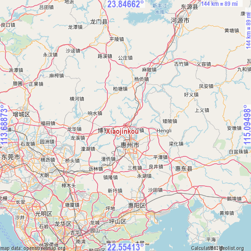
Xiaojinkou GPS coordinates[2]
23° 12' 6.984" North, 114° 23' 30.66" East
| Map corner | latitude | longitude |
|---|---|---|
| Upper-left | 23.84662°, | 113.68873° |
| Center: | 23.20194°, | 114.39185° |
| Lower-right: | 22.55413°, | 115.09498° |
| Map W x H: | 143.7×143.7 km | = 89.3×89.3mi |
| max Lat: | 53.31946° ⇑93.5% North |
| Xiaojinkou: | 23.20194° |
| min Lat: | ⇓6.5% South 18.22056° |
| min Long | Xiaojinkou | max Long |
| 75.07348° | 114.39185° | 134.28917° |
| W 50.9%⇐ | ⇒49.1% E |
Elevation
Elevation of Xiaojinkou is 16 m = 52 ft, and this is 468.8 m = 1538 ft below average elevation for this country.
| Max E: |
5622 m = 18445 ft | 84.9% |
| Avg. | 484.8 m = 1591 ft | |
| Xiaojinkou | 16 m = 52 ft | |
Min E: |
-3 m = -10 ft | 15.1% |
See also: China elevation on elevation.city.
Geographical zone
Xiaojinkou is located in North Torrid zone (between Equator and Tropic of Cancer). Distance of this Northern Tropic circle is 26.1 km =16.2 mi to North.| Distance of | km | miles | from Xiaojinkou |
|---|---|---|---|
| North Pole | 7427.2 | 4615 | to North |
| Arctic Circle | 4821.4 | 2995.9 | to North |
| Tropic Cancer | 26.1 | 16.2 | to North |
| Equator | 2579.8 | 1603 | to South |


Nearby cities:
15 places around Xiaojinkou: (largest is in red/bold)
• Baitang
21.7 km =13.5 mi,  351°
351°
• Chenjiang
21.2 km =13.2 mi,  204°
204°
• Henan’an
14.6 km =9.1 mi,  169°
169°
• Hengli
23.6 km =14.7 mi,  98°
98°
• Huihuan
19 km =11.8 mi,  187°
187°
• Huizhou
10.3 km =6.4 mi, 166°
• Longfeng
14.4 km =8.9 mi,  184°
184°
• Luoyang
12.9 km =8 mi,  250°
250°
• Luzhou
22.7 km =14.1 mi,  36°
36°
• Ma’an
20.7 km =12.9 mi,  146°
146°
• Ruhu
6.3 km =3.9 mi,  109°
109°
• Shuikou
14.3 km =8.9 mi, 111°
• Taimei
15.7 km =9.8 mi,  30°
30°
• Tongqiao
21 km =13 mi, 195°
• Xiangshui
19.2 km =11.9 mi,  292°
292°
Sources, notices
• [Note1] Compared only with cities in China existing in our database
• [Src1] Map data: © OpenStreetMap contributors (CC-BY-SA)
• [Src2] Other city data from geonames.org with taken over terms of usage.
• [Src3] Geographical zone / Annual Mean Temperature by Robert A. Rohde @ Wikipedia
