Aipi geodata
Aipi (Guangdong) is a seat of a fourth-order administrative division; located in China in Asia/Shanghai (GMT+8) time zone. In our database, there are 1268 cities with bigger population. Compared to other cities in China, 93.3% of cities are located further ↑North; 52.3% of cities are located further ←West and 81.6% of cities have higher elevation than Aipi. Note1


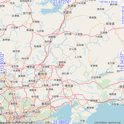
Aipi GPS coordinates[2]
23° 13' 41.52" North, 114° 38' 18.384" East
| Map corner | latitude | longitude |
|---|---|---|
| Upper-left | 23.87276°, | 113.93532° |
| Center: | 23.2282°, | 114.63844° |
| Lower-right: | 22.58052°, | 115.34157° |
| Map W x H: | 143.7×143.7 km | = 89.3×89.3mi |
| max Lat: | 53.31946° ⇑93.3% North |
| Aipi: | 23.2282° |
| min Lat: | ⇓6.7% South 18.22056° |
| min Long | Aipi | max Long |
| 75.07348° | 114.63844° | 134.28917° |
| W 52.3%⇐ | ⇒47.7% E |
Elevation
Elevation of Aipi is 23 m = 75 ft, and this is 461.8 m = 1515 ft below average elevation for this country.
| Max E: |
5622 m = 18445 ft | 81.6% |
| Avg. | 484.8 m = 1591 ft | |
| Aipi | 23 m = 75 ft | |
Min E: |
-3 m = -10 ft | 18.4% |
See also: China elevation on elevation.city.
Geographical zone
Aipi is located in North Torrid zone (between Equator and Tropic of Cancer). Distance of this Northern Tropic circle is 23.2 km =14.4 mi to North.| Distance of | km | miles | from Aipi |
|---|---|---|---|
| North Pole | 7424.3 | 4613.2 | to North |
| Arctic Circle | 4818.4 | 2994 | to North |
| Tropic Cancer | 23.2 | 14.4 | to North |
| Equator | 2582.7 | 1604.8 | to South |


Nearby cities:
15 places around Aipi: (largest is in red/bold)
• Dalan
9.9 km =6.2 mi,  52°
52°
• Daling
24.3 km =15.1 mi,  166°
166°
• Guanyinge
19.9 km =12.4 mi,  341°
341°
• Haoyi
19.8 km =12.3 mi,  36°
36°
• Hengli
6.6 km =4.1 mi,  196°
196°
• Lianghua
13 km =8.1 mi,  161°
161°
• Liangjing
26.1 km =16.2 mi, 196°
• Luzhou
19.3 km =12 mi,  322°
322°
• Ma’an
24.5 km =15.2 mi,  214°
214°
• Pingtan
20.6 km =12.8 mi, 195°
• Ruhu
19.9 km =12.4 mi,  255°
255°
• Shangyi
19.9 km =12.4 mi,  73°
73°
• Shuikou
14.5 km =9 mi,  235°
235°
• Taimei
20.2 km =12.6 mi,  301°
301°
• Xiaojinkou
25.4 km =15.8 mi, 263°
Sources, notices
• [Note1] Compared only with cities in China existing in our database
• [Src1] Map data: © OpenStreetMap contributors (CC-BY-SA)
• [Src2] Other city data from geonames.org with taken over terms of usage.
• [Src3] Geographical zone / Annual Mean Temperature by Robert A. Rohde @ Wikipedia
