Xiaomo geodata
Xiaomo (Guangdong) is a seat of a fourth-order administrative division; located in China in Asia/Shanghai (GMT+8) time zone. In our database, there are 1268 cities with bigger population. Compared to other cities in China, 95.4% of cities are located further ↑North; 54.5% of cities are located further ←West and 86.9% of cities have higher elevation than Xiaomo. Note1


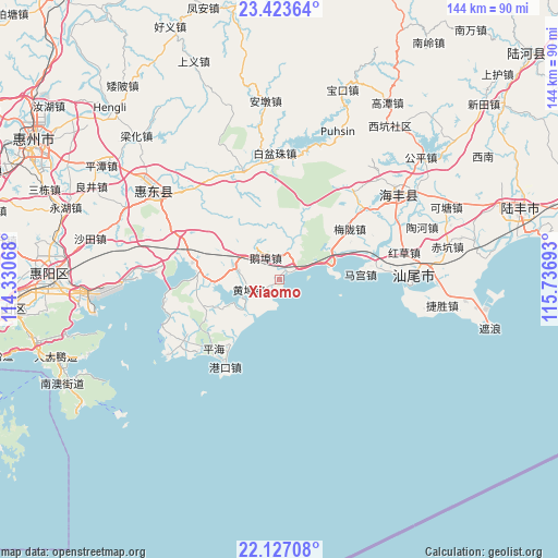
Xiaomo GPS coordinates[2]
22° 46' 36.84" North, 115° 2' 1.68" East
| Map corner | latitude | longitude |
|---|---|---|
| Upper-left | 23.42364°, | 114.33068° |
| Center: | 22.7769°, | 115.0338° |
| Lower-right: | 22.12708°, | 115.73693° |
| Map W x H: | 144.2×144.2 km | = 89.6×89.6mi |
| max Lat: | 53.31946° ⇑95.4% North |
| Xiaomo: | 22.7769° |
| min Lat: | ⇓4.6% South 18.22056° |
| min Long | Xiaomo | max Long |
| 75.07348° | 115.0338° | 134.28917° |
| W 54.5%⇐ | ⇒45.5% E |
Elevation
Elevation of Xiaomo is 13 m = 43 ft, and this is 471.8 m = 1548 ft below average elevation for this country.
| Max E: |
5622 m = 18445 ft | 86.9% |
| Avg. | 484.8 m = 1591 ft | |
| Xiaomo | 13 m = 43 ft | |
Min E: |
-3 m = -10 ft | 13.1% |
See also: China elevation on elevation.city.
Geographical zone
Xiaomo is located in North Torrid zone (between Equator and Tropic of Cancer). Distance of this Northern Tropic circle is 73.4 km =45.6 mi to North.| Distance of | km | miles | from Xiaomo |
|---|---|---|---|
| North Pole | 7474.5 | 4644.4 | to North |
| Arctic Circle | 4868.6 | 3025.2 | to North |
| Tropic Cancer | 73.4 | 45.6 | to North |
| Equator | 2532.6 | 1573.7 | to South |


Nearby cities:
15 places around Xiaomo: (largest is in red/bold)
• Chishi
11.5 km =7.1 mi,  22°
22°
• Duozhu
29.5 km =18.3 mi,  342°
342°
• Ebu
7.3 km =4.5 mi,  326°
326°
• Gangkou
26.5 km =16.5 mi,  211°
211°
• Houmen
13 km =8.1 mi,  71°
71°
• Huangbu
8.3 km =5.2 mi,  252°
252°
• Jilong
12.3 km =7.6 mi,  282°
282°
• Lian’an
30.8 km =19.1 mi,  60°
60°
• Magong
21 km =13 mi,  85°
85°
• Meilong
22.2 km =13.8 mi, 55°
• Pinghai
24.3 km =15.1 mi,  223°
223°
• Renshan
24.4 km =15.2 mi,  285°
285°
• Tieyong
20.4 km =12.7 mi, 254°
• Yanzhou
11.3 km =7 mi,  239°
239°
• Zengguang
31.5 km =19.6 mi, 328°
Sources, notices
• [Note1] Compared only with cities in China existing in our database
• [Src1] Map data: © OpenStreetMap contributors (CC-BY-SA)
• [Src2] Other city data from geonames.org with taken over terms of usage.
• [Src3] Geographical zone / Annual Mean Temperature by Robert A. Rohde @ Wikipedia
