Tieyong geodata
Tieyong (Guangdong) is a seat of a fourth-order administrative division; located in China in Asia/Shanghai (GMT+8) time zone. In our database, there are 1268 cities with bigger population. Compared to other cities in China, 95.5% of cities are located further ↑North; 53.3% of cities are located further ←West and 92.7% of cities have higher elevation than Tieyong. Note1


Tieyong GPS coordinates[2]
22° 43' 44.256" North, 114° 50' 32.028" East
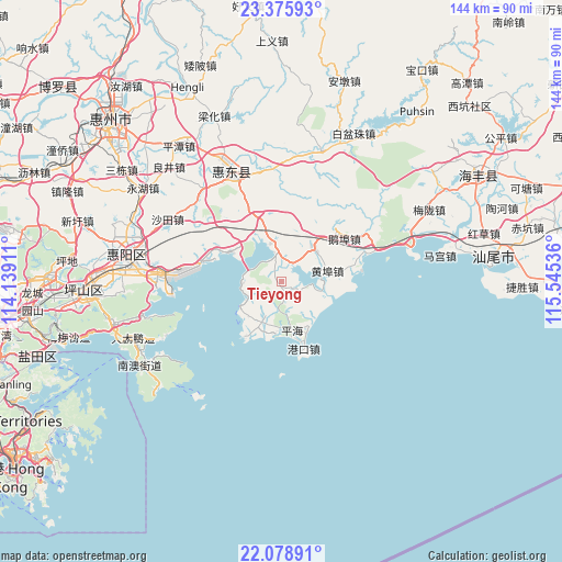
| Map corner | latitude | longitude |
|---|---|---|
| Upper-left | 23.37593°, | 114.13911° |
| Center: | 22.72896°, | 114.84223° |
| Lower-right: | 22.07891°, | 115.54536° |
| Map W x H: | 144.2×144.2 km | = 89.6×89.6mi |
| max Lat: | 53.31946° ⇑95.5% North |
| Tieyong: | 22.72896° |
| min Lat: | ⇓4.5% South 18.22056° |
| min Long | Tieyong | max Long |
| 75.07348° | 114.84223° | 134.28917° |
| W 53.3%⇐ | ⇒46.7% E |
Elevation
Elevation of Tieyong is 8 m = 26 ft, and this is 476.8 m = 1564 ft below average elevation for this country.
| Max E: |
5622 m = 18445 ft | 92.7% |
| Avg. | 484.8 m = 1591 ft | |
| Tieyong | 8 m = 26 ft | |
Min E: |
-3 m = -10 ft | 7.3% |
See also: China elevation on elevation.city.
Geographical zone
Tieyong is located in North Torrid zone (between Equator and Tropic of Cancer). Distance of this Northern Tropic circle is 78.7 km =48.9 mi to North.| Distance of | km | miles | from Tieyong |
|---|---|---|---|
| North Pole | 7479.8 | 4647.7 | to North |
| Arctic Circle | 4874 | 3028.6 | to North |
| Tropic Cancer | 78.7 | 48.9 | to North |
| Equator | 2527.2 | 1570.3 | to South |


Nearby cities:
15 places around Tieyong: (largest is in red/bold)
• Aotou
31.5 km =19.6 mi,  269°
269°
• Baihua
32 km =19.9 mi,  321°
321°
• Chishi
28.9 km =18 mi,  56°
56°
• Ebu
19.3 km =12 mi,  53°
53°
• Gangkou
18.1 km =11.2 mi,  161°
161°
• Houmen
33.4 km =20.8 mi,  73°
73°
• Huangbu
12.1 km =7.5 mi,  76°
76°
• Jilong
11 km =6.8 mi,  44°
44°
• Pinghai
12.8 km =8 mi,  166°
166°
• Pingshan
32.3 km =20.1 mi,  335°
335°
• Renshan
12.5 km =7.8 mi, 342°
• Xiaomo
20.4 km =12.7 mi, 74°
• Xiayong
20.9 km =13 mi,  288°
288°
• Yanzhou
9.9 km =6.2 mi,  92°
92°
• Zengguang
32.3 km =20.1 mi,  5°
5°
Sources, notices
• [Note1] Compared only with cities in China existing in our database
• [Src1] Map data: © OpenStreetMap contributors (CC-BY-SA)
• [Src2] Other city data from geonames.org with taken over terms of usage.
• [Src3] Geographical zone / Annual Mean Temperature by Robert A. Rohde @ Wikipedia
