Baojia geodata
Baojia (Liaoning) is a seat of a fourth-order administrative division; located in China in Asia/Shanghai (GMT+8) time zone. In our database, there are 1268 cities with bigger population. Compared to other cities in China, 90.1% of cities are located further ↓South; 90.6% of cities are located further ←West and 70.5% of cities have higher elevation than Baojia. Note1


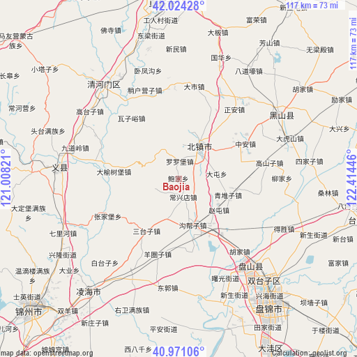
Baojia GPS coordinates[2]
41° 29' 59.316" North, 121° 42' 40.788" East
| Map corner | latitude | longitude |
|---|---|---|
| Upper-left | 42.02428°, | 121.00821° |
| Center: | 41.49981°, | 121.71133° |
| Lower-right: | 40.97106°, | 122.41446° |
| Map W x H: | 117.1×117.1 km | = 72.8×72.8mi |
| max Lat: | 53.31946° ⇑9.9% North |
| Baojia: | 41.49981° |
| min Lat: | ⇓90.1% South 18.22056° |
| min Long | Baojia | max Long |
| 75.07348° | 121.71133° | 134.28917° |
| W 90.6%⇐ | ⇒9.4% E |
Elevation
Elevation of Baojia is 50 m = 164 ft, and this is 434.8 m = 1427 ft below average elevation for this country.
| Max E: |
5622 m = 18445 ft | 70.5% |
| Avg. | 484.8 m = 1591 ft | |
| Baojia | 50 m = 164 ft | |
Min E: |
-3 m = -10 ft | 29.5% |
See also: China elevation on elevation.city.
Geographical zone
Baojia is located in North temperate zone (between Tropic of Cancer and the Arctic Circle). Distance of this Northern Tropic circle is 2008.4 km =1248 mi to South.| Distance of | km | miles | from Baojia |
|---|---|---|---|
| North Pole | 5392.7 | 3350.9 | to North |
| Arctic Circle | 2786.8 | 1731.6 | to North |
| Tropic Cancer | 2008.4 | 1248 | to South |
| Equator | 4614.3 | 2867.2 | to South |


Nearby cities:
15 places around Baojia: (largest is in red/bold)
• Beizhen
12.8 km =8 mi,  33°
33°
• Changxingdian
5.7 km =3.5 mi,  168°
168°
• Dashi
30.8 km =19.1 mi,  9°
9°
• Futun
15.6 km =9.7 mi,  22°
22°
• Gaoshanzi
28.7 km =17.8 mi,  79°
79°
• Goubangzi
15.5 km =9.6 mi,  160°
160°
• Liaotun
5 km =3.1 mi,  109°
109°
• Liujia
33.5 km =20.8 mi,  89°
89°
• Luoluopu
5.9 km =3.7 mi,  2°
2°
• Lüyang
13.6 km =8.5 mi,  195°
195°
• Qingduizi
17.5 km =10.9 mi, 110°
• Wujia
24.4 km =15.2 mi,  100°
100°
• Zhaotun
17.2 km =10.7 mi,  127°
127°
• Zheng’an
29.1 km =18.1 mi,  38°
38°
• Zhong’an
25.2 km =15.7 mi,  62°
62°
Sources, notices
• [Note1] Compared only with cities in China existing in our database
• [Src1] Map data: © OpenStreetMap contributors (CC-BY-SA)
• [Src2] Other city data from geonames.org with taken over terms of usage.
• [Src3] Geographical zone / Annual Mean Temperature by Robert A. Rohde @ Wikipedia
