Zheng’an geodata
Zheng’an (Liaoning) is a seat of a fourth-order administrative division; located in China in Asia/Shanghai (GMT+8) time zone. In our database, there are 1268 cities with bigger population. Compared to other cities in China, 90.5% of cities are located further ↓South; 91% of cities are located further ←West and 71.9% of cities have higher elevation than Zheng’an. Note1


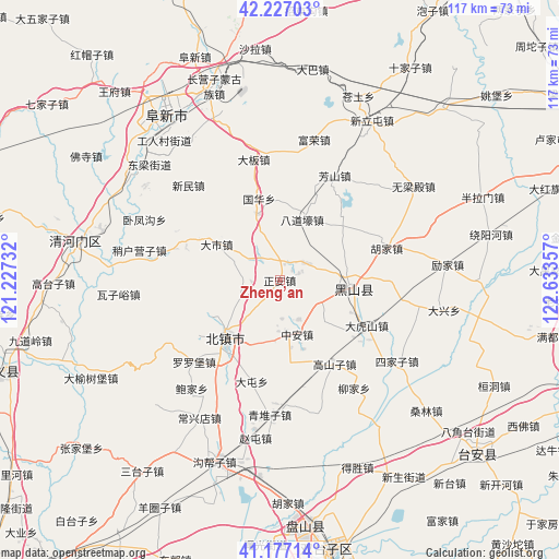
Zheng’an GPS coordinates[2]
41° 42' 15.228" North, 121° 55' 49.584" East
| Map corner | latitude | longitude |
|---|---|---|
| Upper-left | 42.22703°, | 121.22732° |
| Center: | 41.70423°, | 121.93044° |
| Lower-right: | 41.17714°, | 122.63357° |
| Map W x H: | 116.7×116.7 km | = 72.5×72.5mi |
| max Lat: | 53.31946° ⇑9.5% North |
| Zheng’an: | 41.70423° |
| min Lat: | ⇓90.5% South 18.22056° |
| min Long | Zheng’an | max Long |
| 75.07348° | 121.93044° | 134.28917° |
| W 91%⇐ | ⇒9% E |
Elevation
Elevation of Zheng’an is 45 m = 148 ft, and this is 439.8 m = 1443 ft below average elevation for this country.
| Max E: |
5622 m = 18445 ft | 71.9% |
| Avg. | 484.8 m = 1591 ft | |
| Zheng’an | 45 m = 148 ft | |
Min E: |
-3 m = -10 ft | 28.1% |
See also: China elevation on elevation.city.
Geographical zone
Zheng’an is located in North temperate zone (between Tropic of Cancer and the Arctic Circle). Distance of this Northern Tropic circle is 2031.2 km =1262.1 mi to South.| Distance of | km | miles | from Zheng’an |
|---|---|---|---|
| North Pole | 5370 | 3336.8 | to North |
| Arctic Circle | 2764.1 | 1717.5 | to North |
| Tropic Cancer | 2031.2 | 1262.1 | to South |
| Equator | 4637.1 | 2881.4 | to South |


Nearby cities:
15 places around Zheng’an: (largest is in red/bold)
• Baojia
29.1 km =18.1 mi,  218°
218°
• Beizhen
16.4 km =10.2 mi, 222°
• Changxingdian
33.1 km =20.6 mi,  211°
211°
• Dashi
15.4 km =9.6 mi,  300°
300°
• Futun
14.8 km =9.2 mi,  236°
236°
• Gaoshanzi
20 km =12.4 mi,  150°
150°
• Goubangzi
39.6 km =24.6 mi,  199°
199°
• Heishan
15.2 km =9.4 mi,  96°
96°
• Liaotun
27.9 km =17.3 mi, 209°
• Liujia
27.3 km =17 mi, 146°
• Luoluopu
24.6 km =15.3 mi,  226°
226°
• Qingduizi
28.8 km =17.9 mi,  183°
183°
• Wujia
27.9 km =17.3 mi,  168°
168°
• Zhaotun
33.5 km =20.8 mi,  187°
187°
• Zhong’an
11.7 km =7.3 mi,  159°
159°
Sources, notices
• [Note1] Compared only with cities in China existing in our database
• [Src1] Map data: © OpenStreetMap contributors (CC-BY-SA)
• [Src2] Other city data from geonames.org with taken over terms of usage.
• [Src3] Geographical zone / Annual Mean Temperature by Robert A. Rohde @ Wikipedia
