Futun geodata
Futun (Liaoning) is a seat of a fourth-order administrative division; located in China in Asia/Shanghai (GMT+8) time zone. In our database, there are 1268 cities with bigger population. Compared to other cities in China, 90.4% of cities are located further ↓South; 90.8% of cities are located further ←West and 62.9% of cities have higher elevation than Futun. Note1


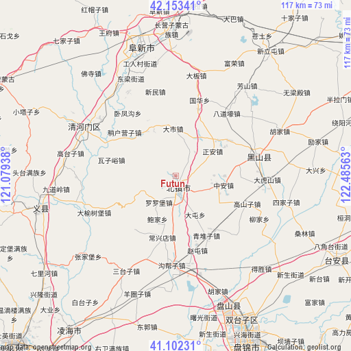
Futun GPS coordinates[2]
41° 37' 48" North, 121° 46' 57" East
| Map corner | latitude | longitude |
|---|---|---|
| Upper-left | 42.15341°, | 121.07938° |
| Center: | 41.63°, | 121.7825° |
| Lower-right: | 41.10231°, | 122.48563° |
| Map W x H: | 116.9×116.9 km | = 72.6×72.6mi |
| max Lat: | 53.31946° ⇑9.6% North |
| Futun: | 41.63° |
| min Lat: | ⇓90.4% South 18.22056° |
| min Long | Futun | max Long |
| 75.07348° | 121.7825° | 134.28917° |
| W 90.8%⇐ | ⇒9.2% E |
Elevation
Elevation of Futun is 83 m = 272 ft, and this is 401.8 m = 1318 ft below average elevation for this country.
| Max E: |
5622 m = 18445 ft | 62.9% |
| Avg. | 484.8 m = 1591 ft | |
| Futun | 83 m = 272 ft | |
Min E: |
-3 m = -10 ft | 37.1% |
See also: China elevation on elevation.city.
Geographical zone
Futun is located in North temperate zone (between Tropic of Cancer and the Arctic Circle). Distance of this Northern Tropic circle is 2022.9 km =1257 mi to South.| Distance of | km | miles | from Futun |
|---|---|---|---|
| North Pole | 5378.2 | 3341.9 | to North |
| Arctic Circle | 2772.4 | 1722.7 | to North |
| Tropic Cancer | 2022.9 | 1257 | to South |
| Equator | 4628.8 | 2876.2 | to South |


Nearby cities:
15 places around Futun: (largest is in red/bold)
• Baojia
15.6 km =9.7 mi,  202°
202°
• Beizhen
4 km =2.5 mi,  162°
162°
• Changxingdian
20.6 km =12.8 mi,  193°
193°
• Dashi
16 km =9.9 mi,  356°
356°
• Gaoshanzi
24 km =14.9 mi,  112°
112°
• Goubangzi
29.1 km =18.1 mi,  181°
181°
• Heishan
28.2 km =17.5 mi,  76°
76°
• Liaotun
16.2 km =10.1 mi, 184°
• Luoluopu
10.3 km =6.4 mi,  213°
213°
• Lüyang
29.2 km =18.1 mi, 199°
• Qingduizi
23 km =14.3 mi,  152°
152°
• Wujia
26.2 km =16.3 mi,  136°
136°
• Zhaotun
26.1 km =16.2 mi, 162°
• Zheng’an
14.8 km =9.2 mi,  56°
56°
• Zhong’an
16.6 km =10.3 mi,  99°
99°
Sources, notices
• [Note1] Compared only with cities in China existing in our database
• [Src1] Map data: © OpenStreetMap contributors (CC-BY-SA)
• [Src2] Other city data from geonames.org with taken over terms of usage.
• [Src3] Geographical zone / Annual Mean Temperature by Robert A. Rohde @ Wikipedia
