Chagang geodata
Chagang (Gansu) is a seat of a fourth-order administrative division; located in China in Asia/Shanghai (GMT+8) time zone. In our database, there are 1268 cities with bigger population. Compared to other cities in China, 68.3% of cities are located further ↓South; 89.9% of cities are located further →East and 94.6% of cities have lower elevation than Chagang. Note1


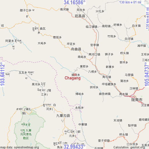
Chagang GPS coordinates[2]
33° 34' 55.488" North, 104° 20' 39.264" East
| Map corner | latitude | longitude |
|---|---|---|
| Upper-left | 34.16586°, | 103.64112° |
| Center: | 33.58208°, | 104.34424° |
| Lower-right: | 32.99433°, | 105.04737° |
| Map W x H: | 130.3×130.3 km | = 81×81mi |
| max Lat: | 53.31946° ⇑31.7% North |
| Chagang: | 33.58208° |
| min Lat: | ⇓68.3% South 18.22056° |
| min Long | Chagang | max Long |
| 75.07348° | 104.34424° | 134.28917° |
| W 10.1%⇐ | ⇒89.9% E |
Elevation
Elevation of Chagang is 1969 m = 6460 ft, and this is 1484.2 m = 4869 ft above average elevation for this country.
| Max E: |
5622 m = 18445 ft | 5.4% |
| Chagang | 1969 m 6460 ft | |
| Avg. | 484.8 m = 1591 ft | |
Min E: |
-3 m = -10 ft | 94.6% |
See also: China elevation on elevation.city.
Geographical zone
Chagang is located in North temperate zone (between Tropic of Cancer and the Arctic Circle). Distance of this Northern Tropic circle is 1128.1 km =701 mi to South.| Distance of | km | miles | from Chagang |
|---|---|---|---|
| North Pole | 6273.1 | 3897.9 | to North |
| Arctic Circle | 3667.2 | 2278.7 | to North |
| Tropic Cancer | 1128.1 | 701 | to South |
| Equator | 3734 | 2320.2 | to South |


Nearby cities:
15 places around Chagang: (largest is in red/bold)
• Baleng
15.9 km =9.9 mi,  79°
79°
• Boyu
17.2 km =10.7 mi,  165°
165°
• Chigan
11.4 km =7.1 mi,  57°
57°
• Dachuan
17.2 km =10.7 mi,  29°
29°
• Fengdie
27 km =16.8 mi,  340°
340°
• Gongba
20.2 km =12.6 mi,  122°
122°
• Gongzishi
21.3 km =13.2 mi,  23°
23°
• Huama
25 km =15.5 mi,  46°
46°
• Jiangpan
21.9 km =13.6 mi,  4°
4°
• Nanyu
16.4 km =10.2 mi, 22°
• Sanjiaoping
11 km =6.8 mi, 47°
• Shawan
20.9 km =13 mi, 76°
• Wuping
5.2 km =3.2 mi,  351°
351°
• Zhongpai
22.3 km =13.9 mi,  40°
40°
• Zhouqu Chengguanzhen
22.5 km =14 mi, 4°
Sources, notices
• [Note1] Compared only with cities in China existing in our database
• [Src1] Map data: © OpenStreetMap contributors (CC-BY-SA)
• [Src2] Other city data from geonames.org with taken over terms of usage.
• [Src3] Geographical zone / Annual Mean Temperature by Robert A. Rohde @ Wikipedia
