Baleng geodata
Baleng (Gansu) is a seat of a fourth-order administrative division; located in China in Asia/Shanghai (GMT+8) time zone. In our database, there are 1268 cities with bigger population. Compared to other cities in China, 68.4% of cities are located further ↓South; 89.7% of cities are located further →East and 92.3% of cities have lower elevation than Baleng. Note1


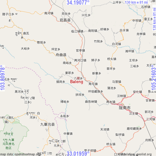
Baleng GPS coordinates[2]
33° 36' 25.812" North, 104° 30' 46.44" East
| Map corner | latitude | longitude |
|---|---|---|
| Upper-left | 34.19077°, | 103.80978° |
| Center: | 33.60717°, | 104.5129° |
| Lower-right: | 33.01959°, | 105.21603° |
| Map W x H: | 130.2×130.2 km | = 80.9×80.9mi |
| max Lat: | 53.31946° ⇑31.6% North |
| Baleng: | 33.60717° |
| min Lat: | ⇓68.4% South 18.22056° |
| min Long | Baleng | max Long |
| 75.07348° | 104.5129° | 134.28917° |
| W 10.3%⇐ | ⇒89.7% E |
Elevation
Elevation of Baleng is 1610 m = 5282 ft, and this is 1125.2 m = 3692 ft above average elevation for this country.
| Max E: |
5622 m = 18445 ft | 7.7% |
| Baleng | 1610 m 5282 ft | |
| Avg. | 484.8 m = 1591 ft | |
Min E: |
-3 m = -10 ft | 92.3% |
See also: China elevation on elevation.city.
Geographical zone
Baleng is located in North temperate zone (between Tropic of Cancer and the Arctic Circle). Distance of this Northern Tropic circle is 1130.8 km =702.6 mi to South.| Distance of | km | miles | from Baleng |
|---|---|---|---|
| North Pole | 6270.3 | 3896.2 | to North |
| Arctic Circle | 3664.4 | 2277 | to North |
| Tropic Cancer | 1130.8 | 702.6 | to South |
| Equator | 3736.8 | 2321.9 | to South |


Nearby cities:
15 places around Baleng: (largest is in red/bold)
• Chagang
15.9 km =9.9 mi,  259°
259°
• Chigan
6.8 km =4.2 mi,  298°
298°
• Dachuan
14 km =8.7 mi,  329°
329°
• Gongba
13.7 km =8.5 mi,  173°
173°
• Gongzishi
18.3 km =11.4 mi,  336°
336°
• Huama
14.6 km =9.1 mi,  9°
9°
• Jiaogong
13.2 km =8.2 mi,  110°
110°
• Nanyu
15.4 km =9.6 mi,  323°
323°
• Pingya
18.1 km =11.2 mi,  127°
127°
• Sanjiaoping
8.8 km =5.5 mi, 301°
• Shawan
5.2 km =3.2 mi,  64°
64°
• Taiyu
20.3 km =12.6 mi,  4°
4°
• Wuping
16.5 km =10.3 mi,  278°
278°
• Xinzhai
16.3 km =10.1 mi,  75°
75°
• Zhongpai
14.3 km =8.9 mi,  355°
355°
Sources, notices
• [Note1] Compared only with cities in China existing in our database
• [Src1] Map data: © OpenStreetMap contributors (CC-BY-SA)
• [Src2] Other city data from geonames.org with taken over terms of usage.
• [Src3] Geographical zone / Annual Mean Temperature by Robert A. Rohde @ Wikipedia
