Puchi geodata
Puchi (Gansu) is a seat of a fourth-order administrative division; located in China in Asia/Shanghai (GMT+8) time zone. In our database, there are 1268 cities with bigger population. Compared to other cities in China, 68.2% of cities are located further ↓South; 89.3% of cities are located further →East and 91% of cities have lower elevation than Puchi. Note1


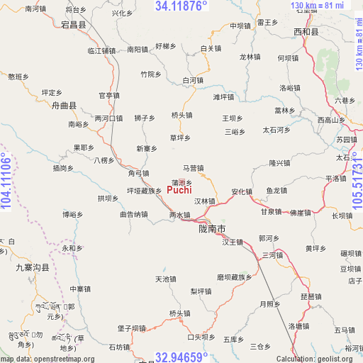
Puchi GPS coordinates[2]
33° 32' 4.776" North, 104° 48' 51.048" East
| Map corner | latitude | longitude |
|---|---|---|
| Upper-left | 34.11876°, | 104.11106° |
| Center: | 33.53466°, | 104.81418° |
| Lower-right: | 32.94659°, | 105.51731° |
| Map W x H: | 130.3×130.3 km | = 81×81mi |
| max Lat: | 53.31946° ⇑31.8% North |
| Puchi: | 33.53466° |
| min Lat: | ⇓68.2% South 18.22056° |
| min Long | Puchi | max Long |
| 75.07348° | 104.81418° | 134.28917° |
| W 10.7%⇐ | ⇒89.3% E |
Elevation
Elevation of Puchi is 1456 m = 4777 ft, and this is 971.2 m = 3186 ft above average elevation for this country.
| Max E: |
5622 m = 18445 ft | 9% |
| Puchi | 1456 m 4777 ft | |
| Avg. | 484.8 m = 1591 ft | |
Min E: |
-3 m = -10 ft | 91% |
See also: China elevation on elevation.city.
Geographical zone
Puchi is located in North temperate zone (between Tropic of Cancer and the Arctic Circle). Distance of this Northern Tropic circle is 1122.8 km =697.7 mi to South.| Distance of | km | miles | from Puchi |
|---|---|---|---|
| North Pole | 6278.4 | 3901.2 | to North |
| Arctic Circle | 3672.5 | 2282 | to North |
| Tropic Cancer | 1122.8 | 697.7 | to South |
| Equator | 3728.7 | 2316.9 | to South |


Nearby cities:
15 places around Puchi: (largest is in red/bold)
• Caoping
16.1 km =10 mi,  358°
358°
• Chiba
12.8 km =8 mi,  346°
346°
• Danian
20.7 km =12.9 mi,  235°
235°
• Dongjiang
21.4 km =13.3 mi,  143°
143°
• Hanlin
10.5 km =6.5 mi,  128°
128°
• Jiaogong
15.9 km =9.9 mi,  282°
282°
• Jinchang
11.9 km =7.4 mi,  39°
39°
• Jinping
14.6 km =9.1 mi,  191°
191°
• Liangshui
11.5 km =7.1 mi,  182°
182°
• Longnan
18 km =11.2 mi,  147°
147°
• Majie
15.7 km =9.8 mi,  122°
122°
• Maying
7.5 km =4.7 mi,  23°
23°
• Pingya
13.7 km =8.5 mi,  257°
257°
• Shimen
8.9 km =5.5 mi,  232°
232°
• Xinzhai
17.1 km =10.6 mi,  315°
315°
Sources, notices
• [Note1] Compared only with cities in China existing in our database
• [Src1] Map data: © OpenStreetMap contributors (CC-BY-SA)
• [Src2] Other city data from geonames.org with taken over terms of usage.
• [Src3] Geographical zone / Annual Mean Temperature by Robert A. Rohde @ Wikipedia
