Dongjiang geodata
Dongjiang (Gansu) is a seat of a fourth-order administrative division; located in China in Asia/Shanghai (GMT+8) time zone. In our database, there are 1268 cities with bigger population. Compared to other cities in China, 67.7% of cities are located further ↓South; 89.1% of cities are located further →East and 85.5% of cities have lower elevation than Dongjiang. Note1


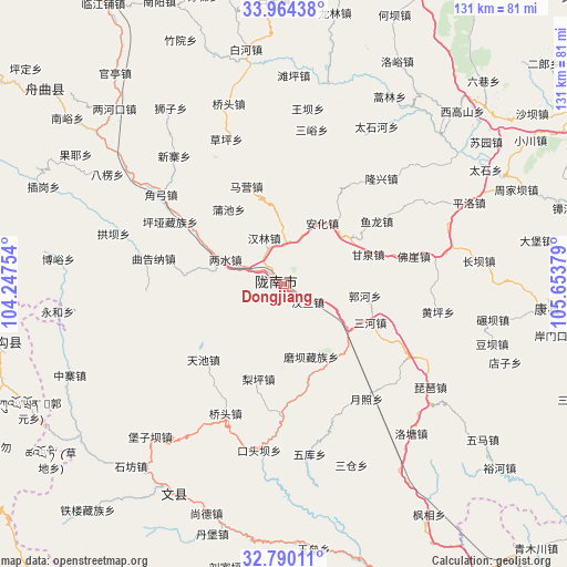
Dongjiang GPS coordinates[2]
33° 22' 45.228" North, 104° 57' 2.376" East
| Map corner | latitude | longitude |
|---|---|---|
| Upper-left | 33.96438°, | 104.24754° |
| Center: | 33.37923°, | 104.95066° |
| Lower-right: | 32.79011°, | 105.65379° |
| Map W x H: | 130.6×130.6 km | = 81.2×81.2mi |
| max Lat: | 53.31946° ⇑32.3% North |
| Dongjiang: | 33.37923° |
| min Lat: | ⇓67.7% South 18.22056° |
| min Long | Dongjiang | max Long |
| 75.07348° | 104.95066° | 134.28917° |
| W 10.9%⇐ | ⇒89.1% E |
Elevation
Elevation of Dongjiang is 1016 m = 3333 ft, and this is 531.2 m = 1743 ft above average elevation for this country.
| Max E: |
5622 m = 18445 ft | 14.5% |
| Dongjiang | 1016 m 3333 ft | |
| Avg. | 484.8 m = 1591 ft | |
Min E: |
-3 m = -10 ft | 85.5% |
See also: China elevation on elevation.city.
Geographical zone
Dongjiang is located in North temperate zone (between Tropic of Cancer and the Arctic Circle). Distance of this Northern Tropic circle is 1105.5 km =686.9 mi to South.| Distance of | km | miles | from Dongjiang |
|---|---|---|---|
| North Pole | 6295.6 | 3911.9 | to North |
| Arctic Circle | 3689.8 | 2292.7 | to North |
| Tropic Cancer | 1105.5 | 686.9 | to South |
| Equator | 3711.4 | 2306.2 | to South |


Nearby cities:
15 places around Dongjiang: (largest is in red/bold)
• Anhua
16.7 km =10.4 mi,  32°
32°
• Ganquan
20.6 km =12.8 mi,  70°
70°
• Guohe
18.7 km =11.6 mi,  99°
99°
• Hanlin
11.6 km =7.2 mi,  337°
337°
• Hanwang
6.9 km =4.3 mi,  125°
125°
• Jiegan
16.8 km =10.4 mi, 126°
• Jinping
15.9 km =9.9 mi,  280°
280°
• Liangshui
14.4 km =8.9 mi,  293°
293°
• Longfeng
9 km =5.6 mi,  78°
78°
• Longnan
3.7 km =2.3 mi,  303°
303°
• Majie
8.9 km =5.5 mi,  4°
4°
• Moba
17.9 km =11.1 mi,  159°
159°
• Sheshu
19.9 km =12.4 mi,  183°
183°
• Toufang
20 km =12.4 mi,  135°
135°
• Waina
21.3 km =13.2 mi,  154°
154°
Sources, notices
• [Note1] Compared only with cities in China existing in our database
• [Src1] Map data: © OpenStreetMap contributors (CC-BY-SA)
• [Src2] Other city data from geonames.org with taken over terms of usage.
• [Src3] Geographical zone / Annual Mean Temperature by Robert A. Rohde @ Wikipedia
