Anhua geodata
Anhua (Gansu) is a seat of a fourth-order administrative division; located in China in Asia/Shanghai (GMT+8) time zone. In our database, there are 1268 cities with bigger population. Compared to other cities in China, 68.1% of cities are located further ↓South; 89% of cities are located further →East and 90.9% of cities have lower elevation than Anhua. Note1


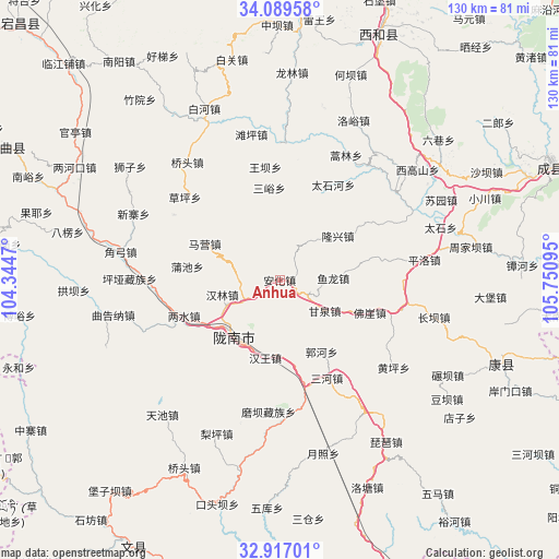
Anhua GPS coordinates[2]
33° 30' 19.008" North, 105° 2' 52.152" East
| Map corner | latitude | longitude |
|---|---|---|
| Upper-left | 34.08958°, | 104.3447° |
| Center: | 33.50528°, | 105.04782° |
| Lower-right: | 32.91701°, | 105.75095° |
| Map W x H: | 130.4×130.4 km | = 81×81mi |
| max Lat: | 53.31946° ⇑31.9% North |
| Anhua: | 33.50528° |
| min Lat: | ⇓68.1% South 18.22056° |
| min Long | Anhua | max Long |
| 75.07348° | 105.04782° | 134.28917° |
| W 11%⇐ | ⇒89% E |
Elevation
Elevation of Anhua is 1442 m = 4731 ft, and this is 957.2 m = 3140 ft above average elevation for this country.
| Max E: |
5622 m = 18445 ft | 9.1% |
| Anhua | 1442 m 4731 ft | |
| Avg. | 484.8 m = 1591 ft | |
Min E: |
-3 m = -10 ft | 90.9% |
See also: China elevation on elevation.city.
Geographical zone
Anhua is located in North temperate zone (between Tropic of Cancer and the Arctic Circle). Distance of this Northern Tropic circle is 1119.5 km =695.6 mi to South.| Distance of | km | miles | from Anhua |
|---|---|---|---|
| North Pole | 6281.6 | 3903.2 | to North |
| Arctic Circle | 3675.7 | 2284 | to North |
| Tropic Cancer | 1119.5 | 695.6 | to South |
| Equator | 3725.4 | 2314.9 | to South |


Nearby cities:
15 places around Anhua: (largest is in red/bold)
• Dongjiang
16.7 km =10.4 mi,  212°
212°
• Foya
22.2 km =13.8 mi,  109°
109°
• Ganquan
12.6 km =7.8 mi,  124°
124°
• Guohe
19.5 km =12.1 mi,  151°
151°
• Hanlin
13.9 km =8.6 mi,  256°
256°
• Hanwang
18.4 km =11.4 mi,  190°
190°
• Jinchang
18.7 km =11.6 mi,  311°
311°
• Longfeng
12.2 km =7.6 mi,  180°
180°
• Longnan
17 km =10.6 mi,  225°
225°
• Longxing
17 km =10.6 mi,  52°
52°
• Majie
9.8 km =6.1 mi,  238°
238°
• Maying
21.3 km =13.2 mi,  298°
298°
• Puchi
21.9 km =13.6 mi,  278°
278°
• Sanyu
21.7 km =13.5 mi,  353°
353°
• Yulong
12.4 km =7.7 mi,  87°
87°
Sources, notices
• [Note1] Compared only with cities in China existing in our database
• [Src1] Map data: © OpenStreetMap contributors (CC-BY-SA)
• [Src2] Other city data from geonames.org with taken over terms of usage.
• [Src3] Geographical zone / Annual Mean Temperature by Robert A. Rohde @ Wikipedia
