Moba geodata
Moba (Gansu) is a seat of a fourth-order administrative division; located in China in Asia/Shanghai (GMT+8) time zone. In our database, there are 1268 cities with bigger population. Compared to other cities in China, 67.1% of cities are located further ↓South; 89.1% of cities are located further →East and 93.8% of cities have lower elevation than Moba. Note1


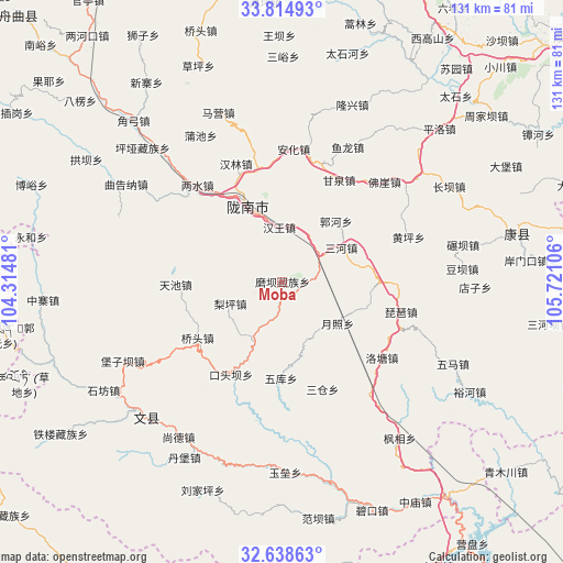
Moba GPS coordinates[2]
33° 13' 43.536" North, 105° 1' 4.548" East
| Map corner | latitude | longitude |
|---|---|---|
| Upper-left | 33.81493°, | 104.31481° |
| Center: | 33.22876°, | 105.01793° |
| Lower-right: | 32.63863°, | 105.72106° |
| Map W x H: | 130.8×130.8 km | = 81.3×81.3mi |
| max Lat: | 53.31946° ⇑32.9% North |
| Moba: | 33.22876° |
| min Lat: | ⇓67.1% South 18.22056° |
| min Long | Moba | max Long |
| 75.07348° | 105.01793° | 134.28917° |
| W 10.9%⇐ | ⇒89.1% E |
Elevation
Elevation of Moba is 1826 m = 5991 ft, and this is 1341.2 m = 4400 ft above average elevation for this country.
| Max E: |
5622 m = 18445 ft | 6.2% |
| Moba | 1826 m 5991 ft | |
| Avg. | 484.8 m = 1591 ft | |
Min E: |
-3 m = -10 ft | 93.8% |
See also: China elevation on elevation.city.
Geographical zone
Moba is located in North temperate zone (between Tropic of Cancer and the Arctic Circle). Distance of this Northern Tropic circle is 1088.8 km =676.5 mi to South.| Distance of | km | miles | from Moba |
|---|---|---|---|
| North Pole | 6312.4 | 3922.3 | to North |
| Arctic Circle | 3706.5 | 2303.1 | to North |
| Tropic Cancer | 1088.8 | 676.5 | to South |
| Equator | 3694.7 | 2295.8 | to South |


Nearby cities:
15 places around Moba: (largest is in red/bold)
• Dongjiang
17.9 km =11.1 mi,  339°
339°
• Guohe
18.2 km =11.3 mi,  41°
41°
• Hanwang
12.7 km =7.9 mi,  356°
356°
• Jiegan
9.9 km =6.2 mi,  46°
46°
• Linjiang
20.6 km =12.8 mi,  205°
205°
• Liping
13.4 km =8.3 mi,  248°
248°
• Longfeng
18.8 km =11.7 mi,  7°
7°
• Longnan
21 km =13 mi,  333°
333°
• Sanhe
15.9 km =9.9 mi,  60°
60°
• Sheshu
8.2 km =5.1 mi, 247°
• Toufang
8 km =5 mi,  72°
72°
• Waina
3.9 km =2.4 mi,  130°
130°
• Wuku
22.2 km =13.8 mi,  181°
181°
• Yuezhao
16.5 km =10.3 mi, 126°
• Yuhuang
20.5 km =12.7 mi, 69°
Sources, notices
• [Note1] Compared only with cities in China existing in our database
• [Src1] Map data: © OpenStreetMap contributors (CC-BY-SA)
• [Src2] Other city data from geonames.org with taken over terms of usage.
• [Src3] Geographical zone / Annual Mean Temperature by Robert A. Rohde @ Wikipedia
