Jiuzhongjin geodata
Jiuzhongjin (Shaanxi) is a seat of a fourth-order administrative division; located in China in Asia/Shanghai (GMT+8) time zone. In our database, there are 1268 cities with bigger population. Compared to other cities in China, 68.1% of cities are located further ↓South; 86.1% of cities are located further →East and 88.7% of cities have lower elevation than Jiuzhongjin. Note1


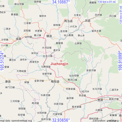
Jiuzhongjin GPS coordinates[2]
33° 31' 28.92" North, 106° 12' 57.096" East
| Map corner | latitude | longitude |
|---|---|---|
| Upper-left | 34.10887°, | 105.51274° |
| Center: | 33.5247°, | 106.21586° |
| Lower-right: | 32.93656°, | 106.91899° |
| Map W x H: | 130.3×130.3 km | = 81×81mi |
| max Lat: | 53.31946° ⇑31.9% North |
| Jiuzhongjin: | 33.5247° |
| min Lat: | ⇓68.1% South 18.22056° |
| min Long | Jiuzhongjin | max Long |
| 75.07348° | 106.21586° | 134.28917° |
| W 13.9%⇐ | ⇒86.1% E |
Elevation
Elevation of Jiuzhongjin is 1244 m = 4081 ft, and this is 759.2 m = 2491 ft above average elevation for this country.
| Max E: |
5622 m = 18445 ft | 11.3% |
| Jiuzhongjin | 1244 m 4081 ft | |
| Avg. | 484.8 m = 1591 ft | |
Min E: |
-3 m = -10 ft | 88.7% |
See also: China elevation on elevation.city.
Geographical zone
Jiuzhongjin is located in North temperate zone (between Tropic of Cancer and the Arctic Circle). Distance of this Northern Tropic circle is 1121.7 km =697 mi to South.| Distance of | km | miles | from Jiuzhongjin |
|---|---|---|---|
| North Pole | 6279.5 | 3901.9 | to North |
| Arctic Circle | 3673.6 | 2282.7 | to North |
| Tropic Cancer | 1121.7 | 697 | to South |
| Equator | 3727.6 | 2316.2 | to South |


Nearby cities:
15 places around Jiuzhongjin: (largest is in red/bold)
• Baishigou
16.8 km =10.4 mi,  187°
187°
• Baishuijiang
12.7 km =7.9 mi,  296°
296°
• Dahedian
21 km =13 mi,  312°
312°
• Hengxianhe
24.1 km =15 mi,  211°
211°
• Jialing
19.5 km =12.1 mi,  354°
354°
• Lianghekou
23.1 km =14.4 mi,  147°
147°
• Lüeyang Chengguanzhen
22.2 km =13.8 mi, 194°
• Matiwan
16.3 km =10.1 mi,  251°
251°
• Shuiyang
27 km =16.8 mi,  337°
337°
• Xiantaiba
20.3 km =12.6 mi,  135°
135°
• Xihuaiba
27.6 km =17.1 mi,  270°
270°
• Xujiaping
19.8 km =12.3 mi,  227°
227°
• Yudongzi
24.3 km =15.1 mi,  155°
155°
• Yuguan
13.1 km =8.1 mi, 339°
• Yunping
26.6 km =16.5 mi,  43°
43°
Sources, notices
• [Note1] Compared only with cities in China existing in our database
• [Src1] Map data: © OpenStreetMap contributors (CC-BY-SA)
• [Src2] Other city data from geonames.org with taken over terms of usage.
• [Src3] Geographical zone / Annual Mean Temperature by Robert A. Rohde @ Wikipedia
