Xieshui geodata
Xieshui (Shaanxi) is a seat of a fourth-order administrative division; located in China in Asia/Shanghai (GMT+8) time zone. In our database, there are 1268 cities with bigger population. Compared to other cities in China, 66.1% of cities are located further ↓South; 84% of cities are located further →East and 75.7% of cities have lower elevation than Xieshui. Note1


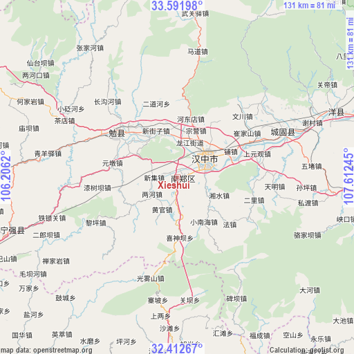
Xieshui GPS coordinates[2]
33° 0' 15.48" North, 106° 54' 33.552" East
| Map corner | latitude | longitude |
|---|---|---|
| Upper-left | 33.59198°, | 106.2062° |
| Center: | 33.0043°, | 106.90932° |
| Lower-right: | 32.41267°, | 107.61245° |
| Map W x H: | 131.1×131.1 km | = 81.5×81.5mi |
| max Lat: | 53.31946° ⇑33.9% North |
| Xieshui: | 33.0043° |
| min Lat: | ⇓66.1% South 18.22056° |
| min Long | Xieshui | max Long |
| 75.07348° | 106.90932° | 134.28917° |
| W 16%⇐ | ⇒84% E |
Elevation
Elevation of Xieshui is 539 m = 1768 ft, and this is 54.2 m = 178 ft above average elevation for this country.
| Max E: |
5622 m = 18445 ft | 24.3% |
| Xieshui | 539 m 1768 ft | |
| Avg. | 484.8 m = 1591 ft | |
Min E: |
-3 m = -10 ft | 75.7% |
See also: China elevation on elevation.city.
Geographical zone
Xieshui is located in North temperate zone (between Tropic of Cancer and the Arctic Circle). Distance of this Northern Tropic circle is 1063.8 km =661 mi to South.| Distance of | km | miles | from Xieshui |
|---|---|---|---|
| North Pole | 6337.3 | 3937.8 | to North |
| Arctic Circle | 3731.4 | 2318.6 | to North |
| Tropic Cancer | 1063.8 | 661 | to South |
| Equator | 3669.7 | 2280.2 | to South |


Nearby cities:
15 places around Xieshui: (largest is in red/bold)
• Changlin
15.5 km =9.6 mi,  358°
358°
• Dahekan
12.5 km =7.8 mi,  70°
70°
• Gaojialing
13.9 km =8.6 mi,  123°
123°
• Gaotai
5.3 km =3.3 mi,  287°
287°
• Guotan
4.5 km =2.8 mi,  31°
31°
• Hanzhong
13.1 km =8.1 mi,  53°
53°
• Hujiaying
10.9 km =6.8 mi,  78°
78°
• Liangshan
9.6 km =6 mi,  18°
18°
• Longjiang
14 km =8.7 mi, 19°
• Nanzheng Chengguanzhen
2.4 km =1.5 mi,  89°
89°
• Qingshu
7.6 km =4.7 mi,  184°
184°
• Renshui
9.7 km =6 mi, 291°
• Xinji
8.2 km =5.1 mi,  272°
272°
• Xinyuan
15 km =9.3 mi, 26°
• Yangchun
3.3 km =2.1 mi,  347°
347°
Sources, notices
• [Note1] Compared only with cities in China existing in our database
• [Src1] Map data: © OpenStreetMap contributors (CC-BY-SA)
• [Src2] Other city data from geonames.org with taken over terms of usage.
• [Src3] Geographical zone / Annual Mean Temperature by Robert A. Rohde @ Wikipedia
