Liuhou geodata
Liuhou (Shaanxi) is a seat of a fourth-order administrative division; located in China in Asia/Shanghai (GMT+8) time zone. In our database, there are 1268 cities with bigger population. Compared to other cities in China, 68.7% of cities are located further ↓South; 84.1% of cities are located further →East and 88.5% of cities have lower elevation than Liuhou. Note1


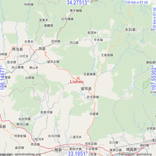
Liuhou GPS coordinates[2]
33° 41' 31.596" North, 106° 50' 59.604" East
| Map corner | latitude | longitude |
|---|---|---|
| Upper-left | 34.27513°, | 106.14677° |
| Center: | 33.69211°, | 106.84989° |
| Lower-right: | 33.1051°, | 107.55302° |
| Map W x H: | 130.1×130.1 km | = 80.8×80.8mi |
| max Lat: | 53.31946° ⇑31.3% North |
| Liuhou: | 33.69211° |
| min Lat: | ⇓68.7% South 18.22056° |
| min Long | Liuhou | max Long |
| 75.07348° | 106.84989° | 134.28917° |
| W 15.9%⇐ | ⇒84.1% E |
Elevation
Elevation of Liuhou is 1230 m = 4035 ft, and this is 745.2 m = 2445 ft above average elevation for this country.
| Max E: |
5622 m = 18445 ft | 11.5% |
| Liuhou | 1230 m 4035 ft | |
| Avg. | 484.8 m = 1591 ft | |
Min E: |
-3 m = -10 ft | 88.5% |
See also: China elevation on elevation.city.
Geographical zone
Liuhou is located in North temperate zone (between Tropic of Cancer and the Arctic Circle). Distance of this Northern Tropic circle is 1140.3 km =708.5 mi to South.| Distance of | km | miles | from Liuhou |
|---|---|---|---|
| North Pole | 6260.9 | 3890.3 | to North |
| Arctic Circle | 3655 | 2271.1 | to North |
| Tropic Cancer | 1140.3 | 708.5 | to South |
| Equator | 3746.2 | 2327.8 | to South |


Nearby cities:
15 places around Liuhou: (largest is in red/bold)
• Fengzhou
36.6 km =22.7 mi,  329°
329°
• Guangjin
33.4 km =20.8 mi,  263°
263°
• Hekou
29.9 km =18.6 mi,  353°
353°
• Huoshaodian
17.9 km =11.1 mi,  158°
158°
• Jiangkou
19 km =11.8 mi,  77°
77°
• Liuba
10.4 km =6.5 mi,  141°
141°
• Madao
32.9 km =20.4 mi,  154°
154°
• Nanxing
18.6 km =11.6 mi,  297°
297°
• Pingkan
23.5 km =14.6 mi,  35°
35°
• Pingmu
36.3 km =22.6 mi,  27°
27°
• Sancha
23.3 km =14.5 mi,  315°
315°
• Taishan
37.4 km =23.2 mi,  283°
283°
• Wenjiangsi
31.7 km =19.7 mi,  294°
294°
• Wuguanyi
19.6 km =12.2 mi, 142°
• Yuhuangmiao
10 km =6.2 mi,  66°
66°
Sources, notices
• [Note1] Compared only with cities in China existing in our database
• [Src1] Map data: © OpenStreetMap contributors (CC-BY-SA)
• [Src2] Other city data from geonames.org with taken over terms of usage.
• [Src3] Geographical zone / Annual Mean Temperature by Robert A. Rohde @ Wikipedia
