Duowa geodata
Duowa (Qinghai) is a seat of a fourth-order administrative division; located in China in Asia/Shanghai (GMT+8) time zone. In our database, there are 1268 cities with bigger population. Compared to other cities in China, 75.4% of cities are located further ↓South; 92.6% of cities are located further →East and 97.5% of cities have lower elevation than Duowa. Note1


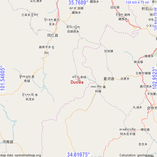
Duowa GPS coordinates[2]
35° 11' 46.896" North, 102° 14' 57.012" East
| Map corner | latitude | longitude |
|---|---|---|
| Upper-left | 35.7689°, | 101.54605° |
| Center: | 35.19636°, | 102.24917° |
| Lower-right: | 34.61975°, | 102.9523° |
| Map W x H: | 127.8×127.8 km | = 79.4×79.4mi |
| max Lat: | 53.31946° ⇑24.6% North |
| Duowa: | 35.19636° |
| min Lat: | ⇓75.4% South 18.22056° |
| min Long | Duowa | max Long |
| 75.07348° | 102.24917° | 134.28917° |
| W 7.4%⇐ | ⇒92.6% E |
Elevation
Elevation of Duowa is 3369 m = 11053 ft, and this is 2884.2 m = 9463 ft above average elevation for this country.
| Max E: |
5622 m = 18445 ft | 2.5% |
| Duowa | 3369 m 11053 ft | |
| Avg. | 484.8 m = 1591 ft | |
Min E: |
-3 m = -10 ft | 97.5% |
See also: China elevation on elevation.city.
Geographical zone
Duowa is located in North temperate zone (between Tropic of Cancer and the Arctic Circle). Distance of this Northern Tropic circle is 1307.5 km =812.4 mi to South.| Distance of | km | miles | from Duowa |
|---|---|---|---|
| North Pole | 6093.6 | 3786.4 | to North |
| Arctic Circle | 3487.7 | 2167.2 | to North |
| Tropic Cancer | 1307.5 | 812.4 | to South |
| Equator | 3913.5 | 2431.7 | to South |


Nearby cities:
15 places around Duowa: (largest is in red/bold)
• Damai
37.7 km =23.4 mi,  89°
89°
• Dogarmo
42.2 km =26.2 mi,  250°
250°
• Duofudu
42.2 km =26.2 mi,  270°
270°
• Ganjia
33.3 km =20.7 mi,  46°
46°
• Jiawu
37.6 km =23.4 mi,  330°
330°
• Jiujia
25.9 km =16.1 mi, 91°
• Labuleng
24.7 km =15.3 mi, 88°
• Qukuhu
35.1 km =21.8 mi,  312°
312°
• Rongwo
41.2 km =25.6 mi, 329°
• Sangke
16.4 km =10.2 mi,  230°
230°
• Sangke
19.4 km =12.1 mi,  114°
114°
• Shuangpengxi
40.8 km =25.4 mi,  353°
353°
• Tawa
33.3 km =20.7 mi,  5°
5°
• Yalang
42.7 km =26.5 mi,  320°
320°
• Zhamao
35.7 km =22.2 mi,  297°
297°
Sources, notices
• [Note1] Compared only with cities in China existing in our database
• [Src1] Map data: © OpenStreetMap contributors (CC-BY-SA)
• [Src2] Other city data from geonames.org with taken over terms of usage.
• [Src3] Geographical zone / Annual Mean Temperature by Robert A. Rohde @ Wikipedia
