Tawa geodata
Tawa (Qinghai) is a seat of a fourth-order administrative division; located in China in Asia/Shanghai (GMT+8) time zone. In our database, there are 1268 cities with bigger population. Compared to other cities in China, 76% of cities are located further ↓South; 92.5% of cities are located further →East and 97.4% of cities have lower elevation than Tawa. Note1


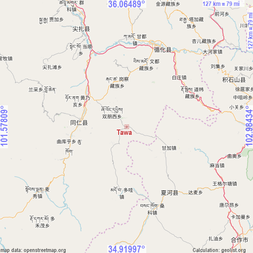
Tawa GPS coordinates[2]
35° 29' 40.092" North, 102° 16' 52.356" East
| Map corner | latitude | longitude |
|---|---|---|
| Upper-left | 36.06489°, | 101.57809° |
| Center: | 35.49447°, | 102.28121° |
| Lower-right: | 34.91997°, | 102.98434° |
| Map W x H: | 127.3×127.3 km | = 79.1×79.1mi |
| max Lat: | 53.31946° ⇑24% North |
| Tawa: | 35.49447° |
| min Lat: | ⇓76% South 18.22056° |
| min Long | Tawa | max Long |
| 75.07348° | 102.28121° | 134.28917° |
| W 7.5%⇐ | ⇒92.5% E |
Elevation
Elevation of Tawa is 3284 m = 10774 ft, and this is 2799.2 m = 9184 ft above average elevation for this country.
| Max E: |
5622 m = 18445 ft | 2.6% |
| Tawa | 3284 m 10774 ft | |
| Avg. | 484.8 m = 1591 ft | |
Min E: |
-3 m = -10 ft | 97.4% |
See also: China elevation on elevation.city.
Geographical zone
Tawa is located in North temperate zone (between Tropic of Cancer and the Arctic Circle). Distance of this Northern Tropic circle is 1340.7 km =833.1 mi to South.| Distance of | km | miles | from Tawa |
|---|---|---|---|
| North Pole | 6060.4 | 3765.8 | to North |
| Arctic Circle | 3454.6 | 2146.6 | to North |
| Tropic Cancer | 1340.7 | 833.1 | to South |
| Equator | 3946.6 | 2452.3 | to South |


Nearby cities:
15 places around Tawa: (largest is in red/bold)
• Baizhuangji
36.5 km =22.7 mi,  46°
46°
• Bao’an
23.6 km =14.7 mi,  305°
305°
• Duowa
33.3 km =20.7 mi,  185°
185°
• Galengkou
23.3 km =14.5 mi,  347°
347°
• Ganjia
23.7 km =14.7 mi,  115°
115°
• Huangnaihai
28.4 km =17.6 mi,  298°
298°
• Jiawu
21.1 km =13.1 mi,  269°
269°
• Laxiong
33.6 km =20.9 mi,  18°
18°
• Nianduhu
23.9 km =14.9 mi,  280°
280°
• Qukuhu
30.5 km =19 mi,  251°
251°
• Rongwo
24.1 km =15 mi, 275°
• Shuangpengxi
10.5 km =6.5 mi, 314°
• Xiagulei
37.4 km =23.2 mi,  61°
61°
• Yaga
30.1 km =18.7 mi,  359°
359°
• Yalang
29.9 km =18.6 mi, 269°
Sources, notices
• [Note1] Compared only with cities in China existing in our database
• [Src1] Map data: © OpenStreetMap contributors (CC-BY-SA)
• [Src2] Other city data from geonames.org with taken over terms of usage.
• [Src3] Geographical zone / Annual Mean Temperature by Robert A. Rohde @ Wikipedia
