Wulie geodata
Wulie (Jiangsu) is a seat of a fourth-order administrative division; located in China in Asia/Shanghai (GMT+8) time zone. In our database, there are 1268 cities with bigger population. Compared to other cities in China, 65.4% of cities are located further ↓South; 83.5% of cities are located further ←West and 99.7% of cities have higher elevation than Wulie. Note1


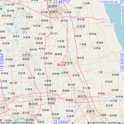
Wulie GPS coordinates[2]
32° 51' 32.616" North, 120° 14' 31.416" East
| Map corner | latitude | longitude |
|---|---|---|
| Upper-left | 33.44772°, | 119.53894° |
| Center: | 32.85906°, | 120.24206° |
| Lower-right: | 32.26647°, | 120.94519° |
| Map W x H: | 131.3×131.3 km | = 81.6×81.6mi |
| max Lat: | 53.31946° ⇑34.6% North |
| Wulie: | 32.85906° |
| min Lat: | ⇓65.4% South 18.22056° |
| min Long | Wulie | max Long |
| 75.07348° | 120.24206° | 134.28917° |
| W 83.5%⇐ | ⇒16.5% E |
Elevation
Elevation of Wulie is 1 m = 3 ft, and this is 483.8 m = 1587 ft below average elevation for this country.
| Max E: |
5622 m = 18445 ft | 99.7% |
| Avg. | 484.8 m = 1591 ft | |
| Wulie | 1 m = 3 ft | |
Min E: |
-3 m = -10 ft | 0.3% |
See also: China elevation on elevation.city.
Geographical zone
Wulie is located in North temperate zone (between Tropic of Cancer and the Arctic Circle). Distance of this Northern Tropic circle is 1047.7 km =651 mi to South.| Distance of | km | miles | from Wulie |
|---|---|---|---|
| North Pole | 6353.5 | 3947.9 | to North |
| Arctic Circle | 3747.6 | 2328.6 | to North |
| Tropic Cancer | 1047.7 | 651 | to South |
| Equator | 3653.6 | 2270.2 | to South |


Nearby cities:
15 places around Wulie: (largest is in red/bold)
• Caoyan
11 km =6.8 mi,  26°
26°
• Changrong
17.8 km =11.1 mi,  302°
302°
• Daiyao
8.2 km =5.1 mi,  341°
341°
• Diduo
15.4 km =9.6 mi,  268°
268°
• Dongtai
6.3 km =3.9 mi,  96°
96°
• Guangshan
6.8 km =4.2 mi,  206°
206°
• Hechen
16.3 km =10.1 mi,  358°
358°
• Liangduo
14.6 km =9.1 mi,  128°
128°
• Lianyi
4.5 km =2.8 mi, 356°
• Sanzao
11.1 km =6.9 mi,  115°
115°
• Shiyan
16.1 km =10 mi,  199°
199°
• Tainan
11.1 km =6.9 mi,  166°
166°
• Tangzi
17.2 km =10.7 mi, 299°
• Taozhuang
9.7 km =6 mi,  275°
275°
• Zhaowanzhuang
14.5 km =9 mi, 209°
Sources, notices
• [Note1] Compared only with cities in China existing in our database
• [Src1] Map data: © OpenStreetMap contributors (CC-BY-SA)
• [Src2] Other city data from geonames.org with taken over terms of usage.
• [Src3] Geographical zone / Annual Mean Temperature by Robert A. Rohde @ Wikipedia
