Dongtai geodata
Dongtai (Jiangsu) is a seat of a third-order administrative division; located in China in Asia/Shanghai (GMT+8) time zone. With population of 110,988 people, there are 390 cities with bigger population in this country. Compared to other cities in China, 65.3% of cities are located further ↓South; 84% of cities are located further ←West and 94.3% of cities have higher elevation than Dongtai. Note1


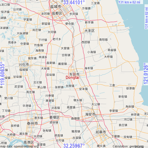
Dongtai GPS coordinates[2]
32° 51' 8.316" North, 120° 18' 34.092" East
| Map corner | latitude | longitude |
|---|---|---|
| Upper-left | 33.44101°, | 119.60635° |
| Center: | 32.85231°, | 120.30947° |
| Lower-right: | 32.25967°, | 121.0126° |
| Map W x H: | 131.4×131.4 km | = 81.6×81.6mi |
| max Lat: | 53.31946° ⇑34.7% North |
| Dongtai: | 32.85231° |
| min Lat: | ⇓65.3% South 18.22056° |
| min Long | Dongtai | max Long |
| 75.07348° | 120.30947° | 134.28917° |
| W 84%⇐ | ⇒16% E |
Elevation
Elevation of Dongtai is 7 m = 23 ft, and this is 477.8 m = 1568 ft below average elevation for this country.
| Max E: |
5622 m = 18445 ft | 94.3% |
| Avg. | 484.8 m = 1591 ft | |
| Dongtai | 7 m = 23 ft | |
Min E: |
-3 m = -10 ft | 5.7% |
See also: Dongtai elevation on elevation.city.
Geographical zone
Dongtai is located in North temperate zone (between Tropic of Cancer and the Arctic Circle). Distance of this Northern Tropic circle is 1046.9 km =650.5 mi to South.| Distance of | km | miles | from Dongtai |
|---|---|---|---|
| North Pole | 6354.2 | 3948.3 | to North |
| Arctic Circle | 3748.3 | 2329.1 | to North |
| Tropic Cancer | 1046.9 | 650.5 | to South |
| Equator | 3652.8 | 2269.7 | to South |


Nearby cities:
15 places around Dongtai: (largest is in red/bold)
• Anfeng
15.7 km =9.8 mi,  147°
147°
• Caoyan
10.7 km =6.6 mi,  352°
352°
• Daiyao
12.3 km =7.6 mi,  313°
313°
• Guangshan
10.7 km =6.6 mi,  240°
240°
• Haifeng
14.2 km =8.8 mi,  66°
66°
• Hechen
18.4 km =11.4 mi,  338°
338°
• Liangduo
9.9 km =6.2 mi, 149°
• Lianyi
8.4 km =5.2 mi, 308°
• Sanzao
5.5 km =3.4 mi,  136°
136°
• Shiyan
18.6 km =11.6 mi,  219°
219°
• Sizao
14.3 km =8.9 mi,  91°
91°
• Tainan
10.7 km =6.6 mi,  200°
200°
• Taozhuang
16 km =9.9 mi,  275°
275°
• Wulie
6.3 km =3.9 mi, 276°
• Zhaowanzhuang
17.9 km =11.1 mi,  228°
228°
Sources, notices
• [Note1] Compared only with cities in China existing in our database
• [Src1] Map data: © OpenStreetMap contributors (CC-BY-SA)
• [Src2] Other city data from geonames.org with taken over terms of usage.
• [Src3] Geographical zone / Annual Mean Temperature by Robert A. Rohde @ Wikipedia
