Sipeng geodata
Sipeng (Jilin) is a seat of a fourth-order administrative division; located in China in Asia/Shanghai (GMT+8) time zone. In our database, there are 1268 cities with bigger population. Compared to other cities in China, 90.8% of cities are located further ↓South; 95.1% of cities are located further ←West and 74.9% of cities have lower elevation than Sipeng. Note1


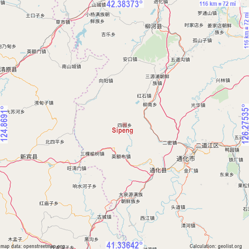
Sipeng GPS coordinates[2]
41° 51' 43.992" North, 125° 34' 19.992" East
| Map corner | latitude | longitude |
|---|---|---|
| Upper-left | 42.38373°, | 124.8691° |
| Center: | 41.86222°, | 125.57222° |
| Lower-right: | 41.33642°, | 126.27535° |
| Map W x H: | 116.4×116.4 km | = 72.3×72.3mi |
| max Lat: | 53.31946° ⇑9.2% North |
| Sipeng: | 41.86222° |
| min Lat: | ⇓90.8% South 18.22056° |
| min Long | Sipeng | max Long |
| 75.07348° | 125.57222° | 134.28917° |
| W 95.1%⇐ | ⇒4.9% E |
Elevation
Elevation of Sipeng is 519 m = 1703 ft, and this is 34.2 m = 112 ft above average elevation for this country.
| Max E: |
5622 m = 18445 ft | 25.1% |
| Sipeng | 519 m 1703 ft | |
| Avg. | 484.8 m = 1591 ft | |
Min E: |
-3 m = -10 ft | 74.9% |
See also: China elevation on elevation.city.
Geographical zone
Sipeng is located in North temperate zone (between Tropic of Cancer and the Arctic Circle). Distance of this Northern Tropic circle is 2048.7 km =1273 mi to South.| Distance of | km | miles | from Sipeng |
|---|---|---|---|
| North Pole | 5352.4 | 3325.8 | to North |
| Arctic Circle | 2746.5 | 1706.6 | to North |
| Tropic Cancer | 2048.7 | 1273 | to South |
| Equator | 4654.6 | 2892.2 | to South |


Nearby cities:
15 places around Sipeng: (largest is in red/bold)
• Dachuan
35.1 km =21.8 mi,  184°
184°
• Daduling
28.9 km =18 mi,  160°
160°
• Daquanyuan
34.4 km =21.4 mi, 175°
• Erdaojiang
39.3 km =24.4 mi,  104°
104°
• Ermi
22.9 km =14.2 mi,  111°
111°
• Gangou
11.8 km =7.3 mi,  89°
89°
• Guanghua
35.5 km =22.1 mi,  74°
74°
• Hulutao
31.4 km =19.5 mi, 104°
• Jianchanggou
22.3 km =13.9 mi,  243°
243°
• Jindou
20.1 km =12.5 mi,  150°
150°
• Kuaidamao
27 km =16.8 mi, 148°
• Sankeyushu
20.2 km =12.6 mi,  228°
228°
• Tonghua
33.4 km =20.8 mi,  118°
118°
• Tongshanjie
23.1 km =14.4 mi, 96°
• Ying’ebu
14.7 km =9.1 mi,  185°
185°
Sources, notices
• [Note1] Compared only with cities in China existing in our database
• [Src1] Map data: © OpenStreetMap contributors (CC-BY-SA)
• [Src2] Other city data from geonames.org with taken over terms of usage.
• [Src3] Geographical zone / Annual Mean Temperature by Robert A. Rohde @ Wikipedia
