Xiaoshanzi geodata
Xiaoshanzi (Heilongjiang) is a seat of a fourth-order administrative division; located in China in Asia/Shanghai (GMT+8) time zone. In our database, there are 1268 cities with bigger population. Compared to other cities in China, 93.8% of cities are located further ↓South; 97.7% of cities are located further ←West and 54.5% of cities have lower elevation than Xiaoshanzi. Note1


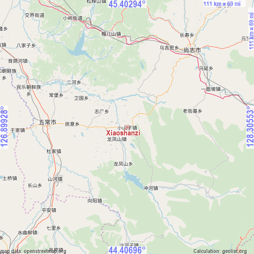
Xiaoshanzi GPS coordinates[2]
44° 54' 25.596" North, 127° 36' 8.64" East
| Map corner | latitude | longitude |
|---|---|---|
| Upper-left | 45.40294°, | 126.89928° |
| Center: | 44.90711°, | 127.6024° |
| Lower-right: | 44.40696°, | 128.30553° |
| Map W x H: | 110.7×110.7 km | = 68.8×68.8mi |
| max Lat: | 53.31946° ⇑6.2% North |
| Xiaoshanzi: | 44.90711° |
| min Lat: | ⇓93.8% South 18.22056° |
| min Long | Xiaoshanzi | max Long |
| 75.07348° | 127.6024° | 134.28917° |
| W 97.7%⇐ | ⇒2.3% E |
Elevation
Elevation of Xiaoshanzi is 201 m = 659 ft, and this is 283.8 m = 931 ft below average elevation for this country.
| Max E: |
5622 m = 18445 ft | 45.5% |
| Avg. | 484.8 m = 1591 ft | |
| Xiaoshanzi | 201 m = 659 ft | |
Min E: |
-3 m = -10 ft | 54.5% |
See also: China elevation on elevation.city.
Geographical zone
Xiaoshanzi is located in North temperate zone (between Tropic of Cancer and the Arctic Circle). Distance of this Northern Tropic circle is 2387.3 km =1483.4 mi to South.| Distance of | km | miles | from Xiaoshanzi |
|---|---|---|---|
| North Pole | 5013.9 | 3115.5 | to North |
| Arctic Circle | 2408 | 1496.3 | to North |
| Tropic Cancer | 2387.3 | 1483.4 | to South |
| Equator | 4993.2 | 3102.6 | to South |


Nearby cities:
15 places around Xiaoshanzi: (largest is in red/bold)
• Anjia
45 km =28 mi,  290°
290°
• Changbao
34 km =21.1 mi, 294°
• Chonghe
28.3 km =17.6 mi,  158°
158°
• Erhe
30 km =18.6 mi,  310°
310°
• Jinma
35.9 km =22.3 mi,  203°
203°
• Laojieji
29.2 km =18.1 mi,  75°
75°
• Longfengshan
15.8 km =9.8 mi,  186°
186°
• Mao’ershan
41.7 km =25.9 mi,  349°
349°
• Minyi
24.1 km =15 mi,  274°
274°
• Shangzhi
44.9 km =27.9 mi,  40°
40°
• Weiguo
23.8 km =14.8 mi,  302°
302°
• Wuchang
35.6 km =22.1 mi, 271°
• Wujimi
39.2 km =24.4 mi,  27°
27°
• Xiangyang
34.9 km =21.7 mi, 204°
• Zhiguang
13.2 km =8.2 mi, 302°
Sources, notices
• [Note1] Compared only with cities in China existing in our database
• [Src1] Map data: © OpenStreetMap contributors (CC-BY-SA)
• [Src2] Other city data from geonames.org with taken over terms of usage.
• [Src3] Geographical zone / Annual Mean Temperature by Robert A. Rohde @ Wikipedia
