Mao’ershan geodata
Mao’ershan (Heilongjiang) is a seat of a fourth-order administrative division; located in China in Asia/Shanghai (GMT+8) time zone. In our database, there are 1268 cities with bigger population. Compared to other cities in China, 94.1% of cities are located further ↓South; 97.6% of cities are located further ←West and 59.4% of cities have lower elevation than Mao’ershan. Note1


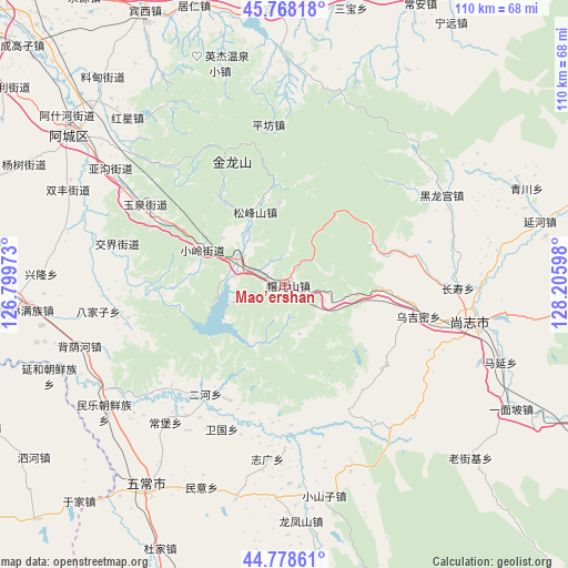
Mao’ershan GPS coordinates[2]
45° 16' 31.98" North, 127° 30' 10.26" East
| Map corner | latitude | longitude |
|---|---|---|
| Upper-left | 45.76818°, | 126.79973° |
| Center: | 45.27555°, | 127.50285° |
| Lower-right: | 44.77861°, | 128.20598° |
| Map W x H: | 110×110 km | = 68.4×68.4mi |
| max Lat: | 53.31946° ⇑5.9% North |
| Mao’ershan: | 45.27555° |
| min Lat: | ⇓94.1% South 18.22056° |
| min Long | Mao’ershan | max Long |
| 75.07348° | 127.50285° | 134.28917° |
| W 97.6%⇐ | ⇒2.4% E |
Elevation
Elevation of Mao’ershan is 252 m = 827 ft, and this is 232.8 m = 764 ft below average elevation for this country.
| Max E: |
5622 m = 18445 ft | 40.6% |
| Avg. | 484.8 m = 1591 ft | |
| Mao’ershan | 252 m = 827 ft | |
Min E: |
-3 m = -10 ft | 59.4% |
See also: China elevation on elevation.city.
Geographical zone
Mao’ershan is located in North temperate zone (between Tropic of Cancer and the Arctic Circle). Distance of this North polar circle is 2367 km =1470.8 mi to North.| Distance of | km | miles | from Mao’ershan |
|---|---|---|---|
| North Pole | 4972.9 | 3090 | to North |
| Arctic Circle | 2367 | 1470.8 | to North |
| Tropic Cancer | 2428.3 | 1508.9 | to South |
| Equator | 5034.2 | 3128.1 | to South |


Nearby cities:
15 places around Mao’ershan: (largest is in red/bold)
• Bajiazi
36.5 km =22.7 mi,  261°
261°
• Changbao
35.3 km =21.9 mi,  220°
220°
• Changshou
33.7 km =20.9 mi,  91°
91°
• Erhe
26.4 km =16.4 mi,  214°
214°
• Heilonggong
35.3 km =21.9 mi,  60°
60°
• Jiaojie
33.3 km =20.7 mi,  283°
283°
• Pingfang
31.1 km =19.3 mi,  354°
354°
• Pingshan
9.8 km =6.1 mi,  302°
302°
• Shangzhi
37.5 km =23.3 mi,  100°
100°
• Songfengshan
15.2 km =9.4 mi,  338°
338°
• Weiguo
30.5 km =19 mi,  203°
203°
• Wujimi
26.8 km =16.7 mi, 103°
• Xiaoling
16.9 km =10.5 mi,  293°
293°
• Yuquan
30.7 km =19.1 mi, 299°
• Zhiguang
34 km =21.1 mi,  185°
185°
Sources, notices
• [Note1] Compared only with cities in China existing in our database
• [Src1] Map data: © OpenStreetMap contributors (CC-BY-SA)
• [Src2] Other city data from geonames.org with taken over terms of usage.
• [Src3] Geographical zone / Annual Mean Temperature by Robert A. Rohde @ Wikipedia
