Shangzhi geodata
Shangzhi (Heilongjiang) is a seat of a third-order administrative division; located in China in Asia/Shanghai (GMT+8) time zone. With population of 82,419 people, there are 519 cities with bigger population in this country. Compared to other cities in China, 94.1% of cities are located further ↓South; 97.9% of cities are located further ←West and 52.5% of cities have lower elevation than Shangzhi. Note1


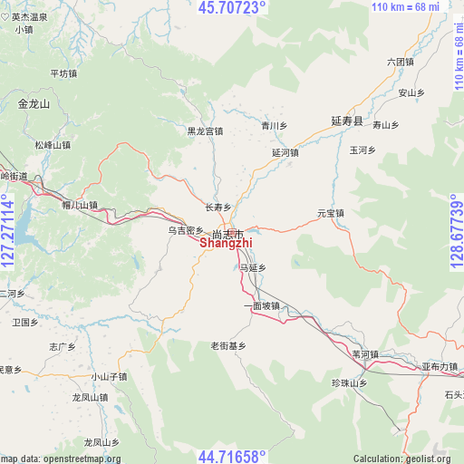
Shangzhi GPS coordinates[2]
45° 12' 50.616" North, 127° 58' 27.336" East
| Map corner | latitude | longitude |
|---|---|---|
| Upper-left | 45.70723°, | 127.27114° |
| Center: | 45.21406°, | 127.97426° |
| Lower-right: | 44.71658°, | 128.67739° |
| Map W x H: | 110.1×110.1 km | = 68.4×68.4mi |
| max Lat: | 53.31946° ⇑5.9% North |
| Shangzhi: | 45.21406° |
| min Lat: | ⇓94.1% South 18.22056° |
| min Long | Shangzhi | max Long |
| 75.07348° | 127.97426° | 134.28917° |
| W 97.9%⇐ | ⇒2.1% E |
Elevation
Elevation of Shangzhi is 185 m = 607 ft, and this is 299.8 m = 984 ft below average elevation for this country.
| Max E: |
5622 m = 18445 ft | 47.5% |
| Avg. | 484.8 m = 1591 ft | |
| Shangzhi | 185 m = 607 ft | |
Min E: |
-3 m = -10 ft | 52.5% |
See also: Shangzhi elevation on elevation.city.
Geographical zone
Shangzhi is located in North temperate zone (between Tropic of Cancer and the Arctic Circle). Distance of this North polar circle is 2373.8 km =1475 mi to North.| Distance of | km | miles | from Shangzhi |
|---|---|---|---|
| North Pole | 4979.7 | 3094.2 | to North |
| Arctic Circle | 2373.8 | 1475 | to North |
| Tropic Cancer | 2421.4 | 1504.6 | to South |
| Equator | 5027.3 | 3123.8 | to South |


Nearby cities:
15 places around Shangzhi: (largest is in red/bold)
• Changshou
7 km =4.3 mi,  332°
332°
• Hedong
6.5 km =4 mi,  43°
43°
• Heilonggong
24.9 km =15.5 mi,  345°
345°
• Laojieji
27 km =16.8 mi,  182°
182°
• Mao’ershan
37.5 km =23.3 mi,  280°
280°
• Qingchuan
27.6 km =17.1 mi,  21°
21°
• Shoushan
44.6 km =27.7 mi,  54°
54°
• Weihe
42.8 km =26.6 mi,  132°
132°
• Wujimi
10.9 km =6.8 mi,  272°
272°
• Xiaoshanzi
44.9 km =27.9 mi,  220°
220°
• Yanhe
23.1 km =14.4 mi,  33°
33°
• Yanshou
38.3 km =23.8 mi, 46°
• Yuanbao
23.9 km =14.9 mi,  78°
78°
• Yuhe
36.7 km =22.8 mi,  57°
57°
• Zhenzhushan
45.4 km =28.2 mi,  141°
141°
Sources, notices
• [Note1] Compared only with cities in China existing in our database
• [Src1] Map data: © OpenStreetMap contributors (CC-BY-SA)
• [Src2] Other city data from geonames.org with taken over terms of usage.
• [Src3] Geographical zone / Annual Mean Temperature by Robert A. Rohde @ Wikipedia
