Yanglin geodata
Yanglin (Heilongjiang) is a seat of a fourth-order administrative division; located in China in Asia/Shanghai (GMT+8) time zone. In our database, there are 1268 cities with bigger population. Compared to other cities in China, 95.1% of cities are located further ↓South; 96.9% of cities are located further ←West and 53.4% of cities have higher elevation than Yanglin. Note1


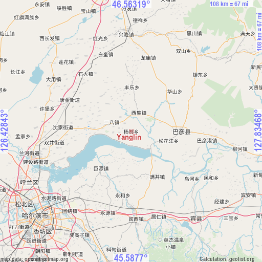
Yanglin GPS coordinates[2]
46° 4' 39.36" North, 127° 7' 53.58" East
| Map corner | latitude | longitude |
|---|---|---|
| Upper-left | 46.56319°, | 126.42843° |
| Center: | 46.0776°, | 127.13155° |
| Lower-right: | 45.5877°, | 127.83468° |
| Map W x H: | 108.5×108.5 km | = 67.4×67.4mi |
| max Lat: | 53.31946° ⇑4.9% North |
| Yanglin: | 46.0776° |
| min Lat: | ⇓95.1% South 18.22056° |
| min Long | Yanglin | max Long |
| 75.07348° | 127.13155° | 134.28917° |
| W 96.9%⇐ | ⇒3.1% E |
Elevation
Elevation of Yanglin is 141 m = 463 ft, and this is 343.8 m = 1128 ft below average elevation for this country.
| Max E: |
5622 m = 18445 ft | 53.4% |
| Avg. | 484.8 m = 1591 ft | |
| Yanglin | 141 m = 463 ft | |
Min E: |
-3 m = -10 ft | 46.6% |
See also: China elevation on elevation.city.
Geographical zone
Yanglin is located in North temperate zone (between Tropic of Cancer and the Arctic Circle). Distance of this North polar circle is 2277.8 km =1415.4 mi to North.| Distance of | km | miles | from Yanglin |
|---|---|---|---|
| North Pole | 4883.7 | 3034.6 | to North |
| Arctic Circle | 2277.8 | 1415.4 | to North |
| Tropic Cancer | 2517.4 | 1564.2 | to South |
| Equator | 5123.3 | 3183.5 | to South |


Nearby cities:
15 places around Yanglin: (largest is in red/bold)
• Bayan
20.6 km =12.8 mi,  90°
90°
• Erba
8.8 km =5.5 mi,  296°
296°
• Fangtai
15.3 km =9.5 mi,  274°
274°
• Fengle
18.3 km =11.4 mi,  1°
1°
• Fujiang
25.6 km =15.9 mi,  101°
101°
• Huashan
24.5 km =15.2 mi,  47°
47°
• Juyuan
19.5 km =12.1 mi,  219°
219°
• Kangjin
28.5 km =17.7 mi, 297°
• Manjing
21.6 km =13.4 mi,  149°
149°
• Shenjia
28.2 km =17.5 mi, 273°
• Songhuajiang
15.6 km =9.7 mi,  106°
106°
• Tangfang
19.6 km =12.2 mi,  197°
197°
• Xiji
8.4 km =5.2 mi,  20°
20°
• Yonghe
26.7 km =16.6 mi,  187°
187°
• Yonghe
27.8 km =17.3 mi,  183°
183°
Sources, notices
• [Note1] Compared only with cities in China existing in our database
• [Src1] Map data: © OpenStreetMap contributors (CC-BY-SA)
• [Src2] Other city data from geonames.org with taken over terms of usage.
• [Src3] Geographical zone / Annual Mean Temperature by Robert A. Rohde @ Wikipedia
