Yonghe geodata
Yonghe (Heilongjiang) is a seat of a fourth-order administrative division; located in China in Asia/Shanghai (GMT+8) time zone. In our database, there are 1268 cities with bigger population. Compared to other cities in China, 94.8% of cities are located further ↓South; 96.8% of cities are located further ←West and 54% of cities have higher elevation than Yonghe. Note1


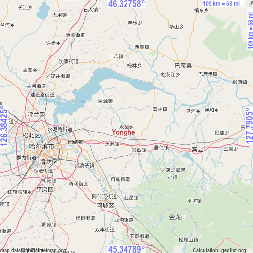
Yonghe GPS coordinates[2]
45° 50' 23.604" North, 127° 5' 14.532" East
| Map corner | latitude | longitude |
|---|---|---|
| Upper-left | 46.32758°, | 126.38425° |
| Center: | 45.83989°, | 127.08737° |
| Lower-right: | 45.34789°, | 127.7905° |
| Map W x H: | 108.9×108.9 km | = 67.7×67.7mi |
| max Lat: | 53.31946° ⇑5.2% North |
| Yonghe: | 45.83989° |
| min Lat: | ⇓94.8% South 18.22056° |
| min Long | Yonghe | max Long |
| 75.07348° | 127.08737° | 134.28917° |
| W 96.8%⇐ | ⇒3.2% E |
Elevation
Elevation of Yonghe is 137 m = 449 ft, and this is 347.8 m = 1141 ft below average elevation for this country.
| Max E: |
5622 m = 18445 ft | 54% |
| Avg. | 484.8 m = 1591 ft | |
| Yonghe | 137 m = 449 ft | |
Min E: |
-3 m = -10 ft | 46% |
See also: China elevation on elevation.city.
Geographical zone
Yonghe is located in North temperate zone (between Tropic of Cancer and the Arctic Circle). Distance of this North polar circle is 2304.3 km =1431.8 mi to North.| Distance of | km | miles | from Yonghe |
|---|---|---|---|
| North Pole | 4910.1 | 3051 | to North |
| Arctic Circle | 2304.3 | 1431.8 | to North |
| Tropic Cancer | 2491 | 1547.8 | to South |
| Equator | 5096.9 | 3167.1 | to South |


Nearby cities:
15 places around Yonghe: (largest is in red/bold)
• Binxi
11.5 km =7.1 mi,  152°
152°
• Fangtai
30.2 km =18.8 mi,  336°
336°
• Feiketu
11.3 km =7 mi,  156°
156°
• Hongxing
30.5 km =19 mi,  176°
176°
• Juren
17.3 km =10.7 mi,  120°
120°
• Juyuan
14.5 km =9 mi,  321°
321°
• Liaodian
23.2 km =14.4 mi,  186°
186°
• Manjing
16.2 km =10.1 mi,  61°
61°
• Niaohe
29.5 km =18.3 mi,  76°
76°
• Songhuajiang
28.6 km =17.8 mi,  40°
40°
• Tangfang
8.1 km =5 mi, 343°
• Xiangyang
16 km =9.9 mi,  232°
232°
• Yanglin
26.7 km =16.6 mi,  7°
7°
• Yonghe
2 km =1.2 mi,  132°
132°
• Yongyuan
9.6 km =6 mi,  219°
219°
Sources, notices
• [Note1] Compared only with cities in China existing in our database
• [Src1] Map data: © OpenStreetMap contributors (CC-BY-SA)
• [Src2] Other city data from geonames.org with taken over terms of usage.
• [Src3] Geographical zone / Annual Mean Temperature by Robert A. Rohde @ Wikipedia
