Zeqin geodata
Zeqin (Jiangxi) is a seat of a fourth-order administrative division; located in China in Asia/Shanghai (GMT+8) time zone. In our database, there are 1268 cities with bigger population. Compared to other cities in China, 83% of cities are located further ↑North; 60.2% of cities are located further ←West and 54.6% of cities have lower elevation than Zeqin. Note1


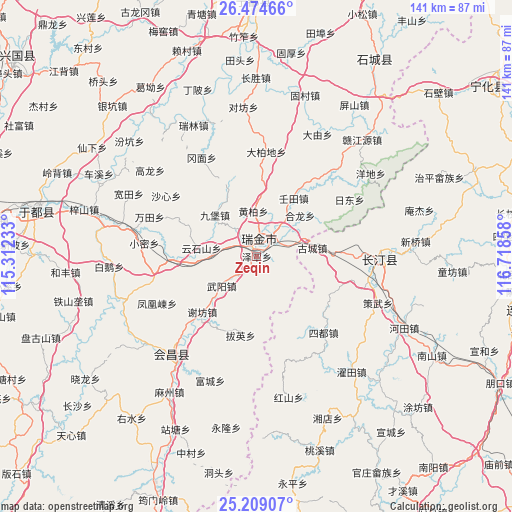
Zeqin GPS coordinates[2]
25° 50' 36.816" North, 116° 0' 55.62" East
| Map corner | latitude | longitude |
|---|---|---|
| Upper-left | 26.47466°, | 115.31233° |
| Center: | 25.84356°, | 116.01545° |
| Lower-right: | 25.20907°, | 116.71858° |
| Map W x H: | 140.7×140.7 km | = 87.4×87.4mi |
| max Lat: | 53.31946° ⇑83% North |
| Zeqin: | 25.84356° |
| min Lat: | ⇓17% South 18.22056° |
| min Long | Zeqin | max Long |
| 75.07348° | 116.01545° | 134.28917° |
| W 60.2%⇐ | ⇒39.8% E |
Elevation
Elevation of Zeqin is 203 m = 666 ft, and this is 281.8 m = 925 ft below average elevation for this country.
| Max E: |
5622 m = 18445 ft | 45.4% |
| Avg. | 484.8 m = 1591 ft | |
| Zeqin | 203 m = 666 ft | |
Min E: |
-3 m = -10 ft | 54.6% |
See also: China elevation on elevation.city.
Geographical zone
Zeqin is located in North temperate zone (between Tropic of Cancer and the Arctic Circle). Distance of this Northern Tropic circle is 267.6 km =166.3 mi to South.| Distance of | km | miles | from Zeqin |
|---|---|---|---|
| North Pole | 7133.5 | 4432.6 | to North |
| Arctic Circle | 4527.6 | 2813.3 | to North |
| Tropic Cancer | 267.6 | 166.3 | to South |
| Equator | 2873.5 | 1785.5 | to South |


Nearby cities:
15 places around Zeqin: (largest is in red/bold)
• Baying
22.3 km =13.9 mi,  191°
191°
• Dabaidi
28.9 km =18 mi,  5°
5°
• Gucheng
15.4 km =9.6 mi,  81°
81°
• Helong
16.3 km =10.1 mi,  46°
46°
• Huangbai
12.5 km =7.8 mi,  355°
355°
• Jiubao
16.2 km =10.1 mi,  314°
314°
• Rentian
18.9 km =11.7 mi,  32°
32°
• Shazhouba
5.1 km =3.2 mi,  334°
334°
• Sidu
27.8 km =17.3 mi,  138°
138°
• Wuyang
12.8 km =8 mi,  229°
229°
• Xianghu
5.1 km =3.2 mi,  197°
197°
• Xiefang
21.4 km =13.3 mi,  224°
224°
• Xijiang
23.5 km =14.6 mi,  268°
268°
• Yeping
8.8 km =5.5 mi,  38°
38°
• Yunshishan
15.4 km =9.6 mi,  278°
278°
Sources, notices
• [Note1] Compared only with cities in China existing in our database
• [Src1] Map data: © OpenStreetMap contributors (CC-BY-SA)
• [Src2] Other city data from geonames.org with taken over terms of usage.
• [Src3] Geographical zone / Annual Mean Temperature by Robert A. Rohde @ Wikipedia
