Xijiang geodata
Xijiang (Jiangxi) is a seat of a fourth-order administrative division; located in China in Asia/Shanghai (GMT+8) time zone. In our database, there are 1268 cities with bigger population. Compared to other cities in China, 83% of cities are located further ↑North; 58.7% of cities are located further ←West and 54% of cities have lower elevation than Xijiang. Note1


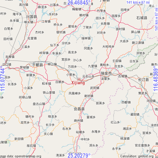
Xijiang GPS coordinates[2]
25° 50' 14.316" North, 115° 46' 50.016" East
| Map corner | latitude | longitude |
|---|---|---|
| Upper-left | 26.46845°, | 115.07744° |
| Center: | 25.83731°, | 115.78056° |
| Lower-right: | 25.20279°, | 116.48369° |
| Map W x H: | 140.7×140.7 km | = 87.4×87.4mi |
| max Lat: | 53.31946° ⇑83% North |
| Xijiang: | 25.83731° |
| min Lat: | ⇓17% South 18.22056° |
| min Long | Xijiang | max Long |
| 75.07348° | 115.78056° | 134.28917° |
| W 58.7%⇐ | ⇒41.3% E |
Elevation
Elevation of Xijiang is 197 m = 646 ft, and this is 287.8 m = 944 ft below average elevation for this country.
| Max E: |
5622 m = 18445 ft | 46% |
| Avg. | 484.8 m = 1591 ft | |
| Xijiang | 197 m = 646 ft | |
Min E: |
-3 m = -10 ft | 54% |
See also: China elevation on elevation.city.
Geographical zone
Xijiang is located in North temperate zone (between Tropic of Cancer and the Arctic Circle). Distance of this Northern Tropic circle is 266.9 km =165.8 mi to South.| Distance of | km | miles | from Xijiang |
|---|---|---|---|
| North Pole | 7134.2 | 4433 | to North |
| Arctic Circle | 4528.3 | 2813.8 | to North |
| Tropic Cancer | 266.9 | 165.8 | to South |
| Equator | 2872.8 | 1785.1 | to South |


Nearby cities:
15 places around Xijiang: (largest is in red/bold)
• Bai’e
17.2 km =10.7 mi,  263°
263°
• Fenghuangdong
12.8 km =8 mi,  197°
197°
• Huanglin
18.3 km =11.4 mi,  299°
299°
• Jiubao
17 km =10.6 mi,  44°
44°
• Kuantian
21.4 km =13.3 mi,  326°
326°
• Shaxin
17.4 km =10.8 mi,  355°
355°
• Shazhouba
21.9 km =13.6 mi,  76°
76°
• Wantian
13 km =8.1 mi, 332°
• Wuyang
15.7 km =9.8 mi,  119°
119°
• Xianghu
22.4 km =13.9 mi,  100°
100°
• Xiaomi
8.6 km =5.3 mi, 300°
• Xiefang
16.9 km =10.5 mi,  149°
149°
• Yunshishan
8.8 km =5.5 mi,  70°
70°
• Zeqin
23.5 km =14.6 mi,  88°
88°
• Zhuangkou
16.6 km =10.3 mi,  228°
228°
Sources, notices
• [Note1] Compared only with cities in China existing in our database
• [Src1] Map data: © OpenStreetMap contributors (CC-BY-SA)
• [Src2] Other city data from geonames.org with taken over terms of usage.
• [Src3] Geographical zone / Annual Mean Temperature by Robert A. Rohde @ Wikipedia
