Xinhe geodata
Xinhe (Jiangxi) is a seat of a fourth-order administrative division; located in China in Asia/Shanghai (GMT+8) time zone. In our database, there are 1268 cities with bigger population. Compared to other cities in China, 58.4% of cities are located further ↑North; 58.6% of cities are located further ←West and 78.3% of cities have higher elevation than Xinhe. Note1


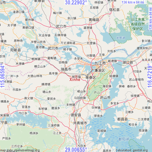
Xinhe GPS coordinates[2]
29° 37' 10.704" North, 115° 46' 8.616" East
| Map corner | latitude | longitude |
|---|---|---|
| Upper-left | 30.22902°, | 115.06594° |
| Center: | 29.61964°, | 115.76906° |
| Lower-right: | 29.00655°, | 116.47219° |
| Map W x H: | 135.9×135.9 km | = 84.4×84.4mi |
| max Lat: | 53.31946° ⇑58.4% North |
| Xinhe: | 29.61964° |
| min Lat: | ⇓41.6% South 18.22056° |
| min Long | Xinhe | max Long |
| 75.07348° | 115.76906° | 134.28917° |
| W 58.6%⇐ | ⇒41.4% E |
Elevation
Elevation of Xinhe is 30 m = 98 ft, and this is 454.8 m = 1492 ft below average elevation for this country.
| Max E: |
5622 m = 18445 ft | 78.3% |
| Avg. | 484.8 m = 1591 ft | |
| Xinhe | 30 m = 98 ft | |
Min E: |
-3 m = -10 ft | 21.7% |
See also: China elevation on elevation.city.
Geographical zone
Xinhe is located in North temperate zone (between Tropic of Cancer and the Arctic Circle). Distance of this Northern Tropic circle is 687.5 km =427.2 mi to South.| Distance of | km | miles | from Xinhe |
|---|---|---|---|
| North Pole | 6713.7 | 4171.7 | to North |
| Arctic Circle | 4107.8 | 2552.5 | to North |
| Tropic Cancer | 687.5 | 427.2 | to South |
| Equator | 3293.4 | 2046.4 | to South |


Nearby cities:
15 places around Xinhe: (largest is in red/bold)
• Baiyang
17.1 km =10.6 mi,  317°
317°
• Chengmen
5 km =3.1 mi,  57°
57°
• Fanzhen
20.2 km =12.6 mi,  258°
258°
• Gangkoujie
11.8 km =7.3 mi,  6°
6°
• Guling
20.8 km =12.9 mi,  105°
105°
• Lianhua
20.5 km =12.7 mi,  83°
83°
• Linquan
18.1 km =11.2 mi,  192°
192°
• Mahuiling
19.5 km =12.1 mi,  170°
170°
• Minshan
12.8 km =8 mi, 188°
• Saiyang
15.7 km =9.8 mi, 106°
• Shahejie
11.5 km =7.1 mi,  96°
96°
• Shizi
6.8 km =4.2 mi, 106°
• Xintang
5.4 km =3.4 mi,  268°
268°
• Yongquan
9.7 km =6 mi, 268°
• Yong’an
16.3 km =10.1 mi, 7°
Sources, notices
• [Note1] Compared only with cities in China existing in our database
• [Src1] Map data: © OpenStreetMap contributors (CC-BY-SA)
• [Src2] Other city data from geonames.org with taken over terms of usage.
• [Src3] Geographical zone / Annual Mean Temperature by Robert A. Rohde @ Wikipedia
