Taishan geodata
Taishan (Jiangxi) is a seat of a fourth-order administrative division; located in China in Asia/Shanghai (GMT+8) time zone. In our database, there are 1268 cities with bigger population. Compared to other cities in China, 76.8% of cities are located further ↑North; 50.2% of cities are located further ←West and 56.9% of cities have lower elevation than Taishan. Note1


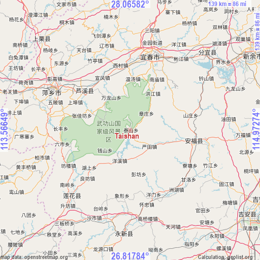
Taishan GPS coordinates[2]
27° 26' 36.924" North, 114° 16' 10.596" East
| Map corner | latitude | longitude |
|---|---|---|
| Upper-left | 28.06582°, | 113.56649° |
| Center: | 27.44359°, | 114.26961° |
| Lower-right: | 26.81784°, | 114.97274° |
| Map W x H: | 138.8×138.8 km | = 86.2×86.2mi |
| max Lat: | 53.31946° ⇑76.8% North |
| Taishan: | 27.44359° |
| min Lat: | ⇓23.2% South 18.22056° |
| min Long | Taishan | max Long |
| 75.07348° | 114.26961° | 134.28917° |
| W 50.2%⇐ | ⇒49.8% E |
Elevation
Elevation of Taishan is 225 m = 738 ft, and this is 259.8 m = 852 ft below average elevation for this country.
| Max E: |
5622 m = 18445 ft | 43.1% |
| Avg. | 484.8 m = 1591 ft | |
| Taishan | 225 m = 738 ft | |
Min E: |
-3 m = -10 ft | 56.9% |
See also: China elevation on elevation.city.
Geographical zone
Taishan is located in North temperate zone (between Tropic of Cancer and the Arctic Circle). Distance of this Northern Tropic circle is 445.5 km =276.8 mi to South.| Distance of | km | miles | from Taishan |
|---|---|---|---|
| North Pole | 6955.6 | 4322 | to North |
| Arctic Circle | 4349.7 | 2702.8 | to North |
| Tropic Cancer | 445.5 | 276.8 | to South |
| Equator | 3051.4 | 1896.1 | to South |


Nearby cities:
15 places around Taishan: (largest is in red/bold)
• Hongjiang
23.1 km =14.4 mi,  31°
31°
• Huayun
19.8 km =12.3 mi,  317°
317°
• Hukeng
5 km =3.1 mi,  49°
49°
• Lukou
24.4 km =15.2 mi,  223°
223°
• Matian
17.7 km =11 mi,  290°
290°
• Pengfang
23.8 km =14.8 mi,  168°
168°
• Qianshan
17.1 km =10.6 mi,  231°
231°
• Shanshi
27 km =16.8 mi, 230°
• Wanlongshan
20.2 km =12.6 mi,  330°
330°
• Xinquan
21.6 km =13.4 mi, 293°
• Yangxi
17.1 km =10.6 mi,  198°
198°
• Yantian
13.5 km =8.4 mi,  129°
129°
• Zhangjiafang
26.9 km =16.7 mi, 287°
• Zhangzhuang
12.7 km =7.9 mi,  43°
43°
• Zhetian
27 km =16.8 mi,  149°
149°
Sources, notices
• [Note1] Compared only with cities in China existing in our database
• [Src1] Map data: © OpenStreetMap contributors (CC-BY-SA)
• [Src2] Other city data from geonames.org with taken over terms of usage.
• [Src3] Geographical zone / Annual Mean Temperature by Robert A. Rohde @ Wikipedia
