Pengfang geodata
Pengfang (Jiangxi) is a seat of a fourth-order administrative division; located in China in Asia/Shanghai (GMT+8) time zone. In our database, there are 1268 cities with bigger population. Compared to other cities in China, 77.6% of cities are located further ↑North; 50.5% of cities are located further ←West and 53.1% of cities have higher elevation than Pengfang. Note1


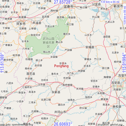
Pengfang GPS coordinates[2]
27° 14' 1.896" North, 114° 19' 0.516" East
| Map corner | latitude | longitude |
|---|---|---|
| Upper-left | 27.85728°, | 113.61369° |
| Center: | 27.23386°, | 114.31681° |
| Lower-right: | 26.60693°, | 115.01994° |
| Map W x H: | 139×139 km | = 86.4×86.4mi |
| max Lat: | 53.31946° ⇑77.6% North |
| Pengfang: | 27.23386° |
| min Lat: | ⇓22.4% South 18.22056° |
| min Long | Pengfang | max Long |
| 75.07348° | 114.31681° | 134.28917° |
| W 50.5%⇐ | ⇒49.5% E |
Elevation
Elevation of Pengfang is 143 m = 469 ft, and this is 341.8 m = 1121 ft below average elevation for this country.
| Max E: |
5622 m = 18445 ft | 53.1% |
| Avg. | 484.8 m = 1591 ft | |
| Pengfang | 143 m = 469 ft | |
Min E: |
-3 m = -10 ft | 46.9% |
See also: China elevation on elevation.city.
Geographical zone
Pengfang is located in North temperate zone (between Tropic of Cancer and the Arctic Circle). Distance of this Northern Tropic circle is 422.2 km =262.3 mi to South.| Distance of | km | miles | from Pengfang |
|---|---|---|---|
| North Pole | 6978.9 | 4336.5 | to North |
| Arctic Circle | 4373.1 | 2717.3 | to North |
| Tropic Cancer | 422.2 | 262.3 | to South |
| Equator | 3028.1 | 1881.6 | to South |


Nearby cities:
15 places around Pengfang: (largest is in red/bold)
• Gaoqiaolou
24.3 km =15.1 mi,  168°
168°
• Gaoshi
25 km =15.5 mi,  206°
206°
• Huaizhong
16.8 km =10.4 mi, 165°
• Jintian
15.2 km =9.4 mi,  127°
127°
• Lianzhou
21.7 km =13.5 mi,  195°
195°
• Longmen
23.5 km =14.6 mi,  227°
227°
• Lukou
22.1 km =13.7 mi,  284°
284°
• Qianshan
22.1 km =13.7 mi,  305°
305°
• Taishan
23.8 km =14.8 mi,  348°
348°
• Xiangxing
14.6 km =9.1 mi,  217°
217°
• Yangmen
13.5 km =8.4 mi,  144°
144°
• Yangxi
12.5 km =7.8 mi,  304°
304°
• Yantian
15.7 km =9.8 mi,  21°
21°
• Zhetian
9 km =5.6 mi,  89°
89°
• Zhouhu
21.8 km =13.5 mi,  112°
112°
Sources, notices
• [Note1] Compared only with cities in China existing in our database
• [Src1] Map data: © OpenStreetMap contributors (CC-BY-SA)
• [Src2] Other city data from geonames.org with taken over terms of usage.
• [Src3] Geographical zone / Annual Mean Temperature by Robert A. Rohde @ Wikipedia
