Hongjiang geodata
Hongjiang (Jiangxi) is a seat of a fourth-order administrative division; located in China in Asia/Shanghai (GMT+8) time zone. In our database, there are 1268 cities with bigger population. Compared to other cities in China, 76.2% of cities are located further ↑North; 51% of cities are located further ←West and 58.1% of cities have lower elevation than Hongjiang. Note1


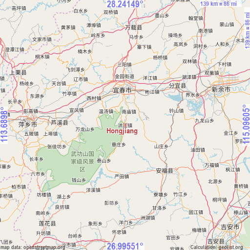
Hongjiang GPS coordinates[2]
27° 37' 12.972" North, 114° 23' 34.512" East
| Map corner | latitude | longitude |
|---|---|---|
| Upper-left | 28.24149°, | 113.6898° |
| Center: | 27.62027°, | 114.39292° |
| Lower-right: | 26.99551°, | 115.09605° |
| Map W x H: | 138.5×138.5 km | = 86.1×86.1mi |
| max Lat: | 53.31946° ⇑76.2% North |
| Hongjiang: | 27.62027° |
| min Lat: | ⇓23.8% South 18.22056° |
| min Long | Hongjiang | max Long |
| 75.07348° | 114.39292° | 134.28917° |
| W 51%⇐ | ⇒49% E |
Elevation
Elevation of Hongjiang is 237 m = 778 ft, and this is 247.8 m = 813 ft below average elevation for this country.
| Max E: |
5622 m = 18445 ft | 41.9% |
| Avg. | 484.8 m = 1591 ft | |
| Hongjiang | 237 m = 778 ft | |
Min E: |
-3 m = -10 ft | 58.1% |
See also: China elevation on elevation.city.
Geographical zone
Hongjiang is located in North temperate zone (between Tropic of Cancer and the Arctic Circle). Distance of this Northern Tropic circle is 465.2 km =289.1 mi to South.| Distance of | km | miles | from Hongjiang |
|---|---|---|---|
| North Pole | 6936 | 4309.8 | to North |
| Arctic Circle | 4330.1 | 2690.6 | to North |
| Tropic Cancer | 465.2 | 289.1 | to South |
| Equator | 3071.1 | 1908.3 | to South |


Nearby cities:
15 places around Hongjiang: (largest is in red/bold)
• Chuntai
20.3 km =12.6 mi,  357°
357°
• Dagangshan
19.6 km =12.2 mi,  78°
78°
• Hukeng
18.4 km =11.4 mi,  206°
206°
• Hutian
23 km =14.3 mi,  348°
348°
• Nanmiao
7.8 km =4.8 mi,  14°
14°
• Shanzhuang
23.2 km =14.4 mi,  119°
119°
• Taishan
23.1 km =14.4 mi, 211°
• Wanlongshan
22.3 km =13.9 mi,  264°
264°
• Wentang
13.3 km =8.3 mi,  307°
307°
• Xiapu
20.2 km =12.6 mi, 14°
• Xicun
22.8 km =14.2 mi, 311°
• Xinfang
11.7 km =7.3 mi,  40°
40°
• Yichun
23.7 km =14.7 mi,  1°
1°
• Yuanzhou
19.9 km =12.4 mi, 355°
• Zhangzhuang
11 km =6.8 mi,  197°
197°
Sources, notices
• [Note1] Compared only with cities in China existing in our database
• [Src1] Map data: © OpenStreetMap contributors (CC-BY-SA)
• [Src2] Other city data from geonames.org with taken over terms of usage.
• [Src3] Geographical zone / Annual Mean Temperature by Robert A. Rohde @ Wikipedia
