Lushan geodata
Lushan (Zhejiang) is a seat of a fourth-order administrative division; located in China in Asia/Shanghai (GMT+8) time zone. In our database, there are 1268 cities with bigger population. Compared to other cities in China, 53.9% of cities are located further ↑North; 81.2% of cities are located further ←West and 79.8% of cities have higher elevation than Lushan. Note1


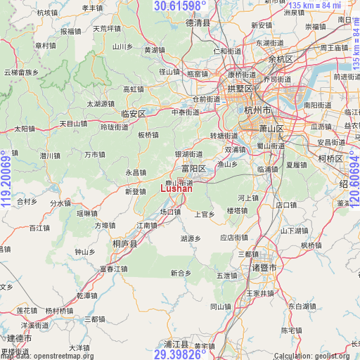
Lushan GPS coordinates[2]
30° 0' 32.364" North, 119° 54' 13.716" East
| Map corner | latitude | longitude |
|---|---|---|
| Upper-left | 30.61598°, | 119.20069° |
| Center: | 30.00899°, | 119.90381° |
| Lower-right: | 29.39826°, | 120.60694° |
| Map W x H: | 135.4×135.4 km | = 84.1×84.1mi |
| max Lat: | 53.31946° ⇑53.9% North |
| Lushan: | 30.00899° |
| min Lat: | ⇓46.1% South 18.22056° |
| min Long | Lushan | max Long |
| 75.07348° | 119.90381° | 134.28917° |
| W 81.2%⇐ | ⇒18.8% E |
Elevation
Elevation of Lushan is 27 m = 89 ft, and this is 457.8 m = 1502 ft below average elevation for this country.
| Max E: |
5622 m = 18445 ft | 79.8% |
| Avg. | 484.8 m = 1591 ft | |
| Lushan | 27 m = 89 ft | |
Min E: |
-3 m = -10 ft | 20.2% |
See also: China elevation on elevation.city.
Geographical zone
Lushan is located in North temperate zone (between Tropic of Cancer and the Arctic Circle). Distance of this Northern Tropic circle is 730.8 km =454.1 mi to South.| Distance of | km | miles | from Lushan |
|---|---|---|---|
| North Pole | 6670.4 | 4144.8 | to North |
| Arctic Circle | 4064.5 | 2525.6 | to North |
| Tropic Cancer | 730.8 | 454.1 | to South |
| Equator | 3336.7 | 2073.3 | to South |


Nearby cities:
15 places around Lushan: (largest is in red/bold)
• Changkou
11 km =6.8 mi,  193°
193°
• Chunjian
10.6 km =6.6 mi,  315°
315°
• Chunjing
6.4 km =4 mi,  65°
65°
• Dayuan
8.8 km =5.5 mi,  92°
92°
• Dongzhou
11 km =6.8 mi,  45°
45°
• Fuyang
6.8 km =4.2 mi,  43°
43°
• Gaoqiao
10.8 km =6.7 mi,  17°
17°
• Huanshan
8.9 km =5.5 mi,  166°
166°
• Lingqiao
12.3 km =7.6 mi,  78°
78°
• Lishan
15.9 km =9.9 mi, 73°
• Longmen
12.5 km =7.8 mi,  160°
160°
• Shoujiang
14.1 km =8.8 mi, 22°
• Xindeng
17.4 km =10.8 mi,  256°
256°
• Xintong
14.3 km =8.9 mi,  217°
217°
• Yongchang
16.9 km =10.5 mi,  281°
281°
Sources, notices
• [Note1] Compared only with cities in China existing in our database
• [Src1] Map data: © OpenStreetMap contributors (CC-BY-SA)
• [Src2] Other city data from geonames.org with taken over terms of usage.
• [Src3] Geographical zone / Annual Mean Temperature by Robert A. Rohde @ Wikipedia
