Shoujiang geodata
Shoujiang (Zhejiang) is a seat of a fourth-order administrative division; located in China in Asia/Shanghai (GMT+8) time zone. In our database, there are 1268 cities with bigger population. Compared to other cities in China, 52.8% of cities are located further ↑North; 81.7% of cities are located further ←West and 75.7% of cities have higher elevation than Shoujiang. Note1


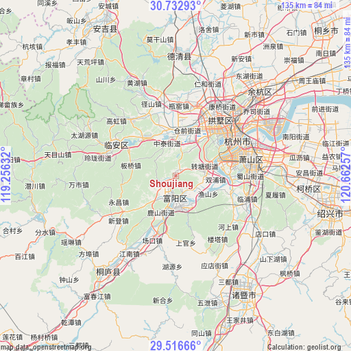
Shoujiang GPS coordinates[2]
30° 7' 36.012" North, 119° 57' 33.984" East
| Map corner | latitude | longitude |
|---|---|---|
| Upper-left | 30.73293°, | 119.25632° |
| Center: | 30.12667°, | 119.95944° |
| Lower-right: | 29.51666°, | 120.66257° |
| Map W x H: | 135.2×135.2 km | = 84×84mi |
| max Lat: | 53.31946° ⇑52.8% North |
| Shoujiang: | 30.12667° |
| min Lat: | ⇓47.2% South 18.22056° |
| min Long | Shoujiang | max Long |
| 75.07348° | 119.95944° | 134.28917° |
| W 81.7%⇐ | ⇒18.3% E |
Elevation
Elevation of Shoujiang is 35 m = 115 ft, and this is 449.8 m = 1476 ft below average elevation for this country.
| Max E: |
5622 m = 18445 ft | 75.7% |
| Avg. | 484.8 m = 1591 ft | |
| Shoujiang | 35 m = 115 ft | |
Min E: |
-3 m = -10 ft | 24.3% |
See also: China elevation on elevation.city.
Geographical zone
Shoujiang is located in North temperate zone (between Tropic of Cancer and the Arctic Circle). Distance of this Northern Tropic circle is 743.9 km =462.2 mi to South.| Distance of | km | miles | from Shoujiang |
|---|---|---|---|
| North Pole | 6657.3 | 4136.7 | to North |
| Arctic Circle | 4051.4 | 2517.4 | to North |
| Tropic Cancer | 743.9 | 462.2 | to South |
| Equator | 3349.8 | 2081.5 | to South |


Nearby cities:
15 places around Shoujiang: (largest is in red/bold)
• Chunjian
14 km =8.7 mi,  246°
246°
• Chunjing
10.4 km =6.5 mi,  177°
177°
• Dayuan
13.8 km =8.6 mi,  165°
165°
• Dongzhou
5.9 km =3.7 mi,  155°
155°
• Fuyang
8.2 km =5.1 mi,  185°
185°
• Gaoqiao
3.5 km =2.2 mi,  218°
218°
• Lingqiao
12.6 km =7.8 mi,  147°
147°
• Lishan
13 km =8.1 mi,  130°
130°
• Lushan
14.1 km =8.8 mi,  202°
202°
• Shuangpu
15.3 km =9.5 mi,  94°
94°
• Xianlin
11.2 km =7 mi,  10°
10°
• Yushan
14.1 km =8.8 mi,  118°
118°
• Zhongtai
13.1 km =8.1 mi,  346°
346°
• Zhoupu
11 km =6.8 mi,  110°
110°
• Zhuantang
11.9 km =7.4 mi,  69°
69°
Sources, notices
• [Note1] Compared only with cities in China existing in our database
• [Src1] Map data: © OpenStreetMap contributors (CC-BY-SA)
• [Src2] Other city data from geonames.org with taken over terms of usage.
• [Src3] Geographical zone / Annual Mean Temperature by Robert A. Rohde @ Wikipedia
