Hutang geodata
Hutang (Zhejiang) is a seat of a fourth-order administrative division; located in China in Asia/Shanghai (GMT+8) time zone. In our database, there are 1268 cities with bigger population. Compared to other cities in China, 53.2% of cities are located further ↑North; 84.6% of cities are located further ←West and 89.9% of cities have higher elevation than Hutang. Note1


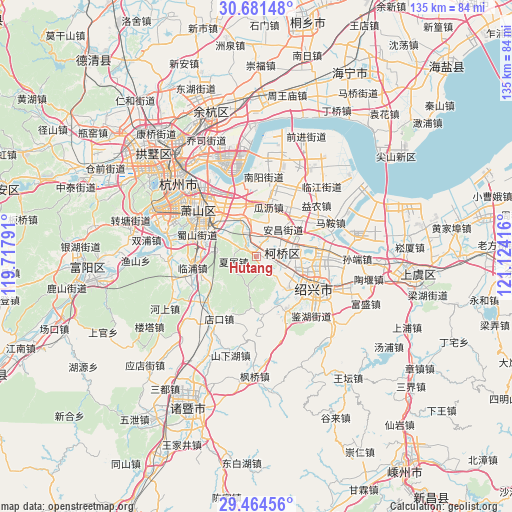
Hutang GPS coordinates[2]
30° 4' 29.604" North, 120° 25' 15.708" East
| Map corner | latitude | longitude |
|---|---|---|
| Upper-left | 30.68148°, | 119.71791° |
| Center: | 30.07489°, | 120.42103° |
| Lower-right: | 29.46456°, | 121.12416° |
| Map W x H: | 135.3×135.3 km | = 84.1×84.1mi |
| max Lat: | 53.31946° ⇑53.2% North |
| Hutang: | 30.07489° |
| min Lat: | ⇓46.8% South 18.22056° |
| min Long | Hutang | max Long |
| 75.07348° | 120.42103° | 134.28917° |
| W 84.6%⇐ | ⇒15.4% E |
Elevation
Elevation of Hutang is 10 m = 33 ft, and this is 474.8 m = 1558 ft below average elevation for this country.
| Max E: |
5622 m = 18445 ft | 89.9% |
| Avg. | 484.8 m = 1591 ft | |
| Hutang | 10 m = 33 ft | |
Min E: |
-3 m = -10 ft | 10.1% |
See also: China elevation on elevation.city.
Geographical zone
Hutang is located in North temperate zone (between Tropic of Cancer and the Arctic Circle). Distance of this Northern Tropic circle is 738.1 km =458.6 mi to South.| Distance of | km | miles | from Hutang |
|---|---|---|---|
| North Pole | 6663 | 4140.2 | to North |
| Arctic Circle | 4057.2 | 2521 | to North |
| Tropic Cancer | 738.1 | 458.6 | to South |
| Equator | 3344 | 2077.9 | to South |


Nearby cities:
15 places around Hutang: (largest is in red/bold)
• Anchang
9.6 km =6 mi,  40°
40°
• Dangshan
13.7 km =8.5 mi, 43°
• Dongpu
10.8 km =6.7 mi,  101°
101°
• Guali
12.8 km =8 mi,  14°
14°
• Huashe
7.2 km =4.5 mi,  54°
54°
• Jinhua
14.5 km =9 mi,  241°
241°
• Jinsanjiao
14 km =8.7 mi,  132°
132°
• Kanshan
13.3 km =8.3 mi,  354°
354°
• Lizhu
14 km =8.7 mi,  161°
161°
• Qianqing
5.8 km =3.6 mi,  344°
344°
• Qixian
12.4 km =7.7 mi,  64°
64°
• Xialu
6.4 km =4 mi,  260°
260°
• Xintang
14 km =8.7 mi,  306°
306°
• Yangxunqiao
9.8 km =6.1 mi,  320°
320°
• Yaqian
9.8 km =6.1 mi, 350°
Sources, notices
• [Note1] Compared only with cities in China existing in our database
• [Src1] Map data: © OpenStreetMap contributors (CC-BY-SA)
• [Src2] Other city data from geonames.org with taken over terms of usage.
• [Src3] Geographical zone / Annual Mean Temperature by Robert A. Rohde @ Wikipedia
