Hezhuang geodata
Hezhuang (Zhejiang) is a seat of a fourth-order administrative division; located in China in Asia/Shanghai (GMT+8) time zone. In our database, there are 1268 cities with bigger population. Compared to other cities in China, 51.2% of cities are located further ↑North; 84.8% of cities are located further ←West and 88.7% of cities have higher elevation than Hezhuang. Note1


Hezhuang GPS coordinates[2]
30° 18' 0.54" North, 120° 27' 39.852" East
| Map corner | latitude | longitude |
|---|---|---|
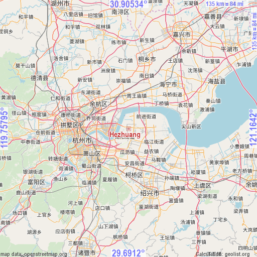
| Upper-left | 30.90534°, | 119.75795° |
| Center: | 30.30015°, | 120.46107° |
| Lower-right: | 29.6912°, | 121.1642° |
| Map W x H: | 135×135 km | = 83.9×83.9mi |
| max Lat: | 53.31946° ⇑51.2% North |
| Hezhuang: | 30.30015° |
| min Lat: | ⇓48.8% South 18.22056° |
| min Long | Hezhuang | max Long |
| 75.07348° | 120.46107° | 134.28917° |
| W 84.8%⇐ | ⇒15.2% E |
Elevation
Elevation of Hezhuang is 11 m = 36 ft, and this is 473.8 m = 1554 ft below average elevation for this country.
| Max E: |
5622 m = 18445 ft | 88.7% |
| Avg. | 484.8 m = 1591 ft | |
| Hezhuang | 11 m = 36 ft | |
Min E: |
-3 m = -10 ft | 11.3% |
See also: China elevation on elevation.city.
Geographical zone
Hezhuang is located in North temperate zone (between Tropic of Cancer and the Arctic Circle). Distance of this Northern Tropic circle is 763.1 km =474.2 mi to South.| Distance of | km | miles | from Hezhuang |
|---|---|---|---|
| North Pole | 6638 | 4124.7 | to North |
| Arctic Circle | 4032.1 | 2505.4 | to North |
| Tropic Cancer | 763.1 | 474.2 | to South |
| Equator | 3369.1 | 2093.5 | to South |


Nearby cities:
15 places around Hezhuang: (largest is in red/bold)
• Chang’an
17.4 km =10.8 mi,  354°
354°
• Dangshan
16.1 km =10 mi,  159°
159°
• Dangwan
11.2 km =7 mi,  134°
134°
• Guali
12.6 km =7.8 mi,  183°
183°
• Jingjiang
7.4 km =4.6 mi, 179°
• Kanshan
12.9 km =8 mi,  203°
203°
• Nanyang
4.5 km =2.8 mi, 203°
• Qiaosi
17.8 km =11.1 mi,  288°
288°
• Xiasha
13.9 km =8.6 mi,  274°
274°
• Xinjie
17.2 km =10.7 mi,  225°
225°
• Xinwan
7.8 km =4.8 mi,  107°
107°
• Xucun
17.6 km =10.9 mi,  328°
328°
• Yaqian
16.3 km =10.1 mi, 199°
• Yinong
16.6 km =10.3 mi, 133°
• Yipeng
5 km =3.1 mi,  148°
148°
Sources, notices
• [Note1] Compared only with cities in China existing in our database
• [Src1] Map data: © OpenStreetMap contributors (CC-BY-SA)
• [Src2] Other city data from geonames.org with taken over terms of usage.
• [Src3] Geographical zone / Annual Mean Temperature by Robert A. Rohde @ Wikipedia
