Tanxi geodata
Tanxi (Jiangxi) is a seat of a fourth-order administrative division; located in China in Asia/Shanghai (GMT+8) time zone. In our database, there are 1268 cities with bigger population. Compared to other cities in China, 77.4% of cities are located further ↑North; 65.6% of cities are located further ←West and 58.1% of cities have higher elevation than Tanxi. Note1


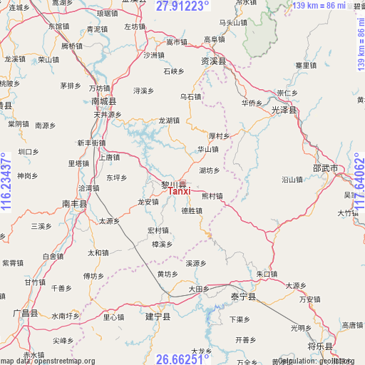
Tanxi GPS coordinates[2]
27° 17' 20.868" North, 116° 56' 14.964" East
| Map corner | latitude | longitude |
|---|---|---|
| Upper-left | 27.91223°, | 116.23437° |
| Center: | 27.28913°, | 116.93749° |
| Lower-right: | 26.66251°, | 117.64062° |
| Map W x H: | 139×139 km | = 86.4×86.4mi |
| max Lat: | 53.31946° ⇑77.4% North |
| Tanxi: | 27.28913° |
| min Lat: | ⇓22.6% South 18.22056° |
| min Long | Tanxi | max Long |
| 75.07348° | 116.93749° | 134.28917° |
| W 65.6%⇐ | ⇒34.4% E |
Elevation
Elevation of Tanxi is 111 m = 364 ft, and this is 373.8 m = 1226 ft below average elevation for this country.
| Max E: |
5622 m = 18445 ft | 58.1% |
| Avg. | 484.8 m = 1591 ft | |
| Tanxi | 111 m = 364 ft | |
Min E: |
-3 m = -10 ft | 41.9% |
See also: China elevation on elevation.city.
Geographical zone
Tanxi is located in North temperate zone (between Tropic of Cancer and the Arctic Circle). Distance of this Northern Tropic circle is 428.3 km =266.1 mi to South.| Distance of | km | miles | from Tanxi |
|---|---|---|---|
| North Pole | 6972.8 | 4332.7 | to North |
| Arctic Circle | 4366.9 | 2713.5 | to North |
| Tropic Cancer | 428.3 | 266.1 | to South |
| Equator | 3034.3 | 1885.4 | to South |


Nearby cities:
15 places around Tanxi: (largest is in red/bold)
• Datian
40.6 km =25.2 mi,  171°
171°
• Dongping
25.3 km =15.7 mi,  275°
275°
• Hongmen
31.8 km =19.8 mi,  315°
315°
• Huangfang
34.9 km =21.7 mi,  189°
189°
• Laixi
36.7 km =22.8 mi,  256°
256°
• Lita
40.5 km =25.2 mi, 281°
• Long’an
14.9 km =9.3 mi,  242°
242°
• Qiawan
35.9 km =22.3 mi,  267°
267°
• Qincheng
41.2 km =25.6 mi, 258°
• Rifeng
2.8 km =1.7 mi,  289°
289°
• Sangtian
40.9 km =25.4 mi, 243°
• Shangtang
29.8 km =18.5 mi, 289°
• Tianjingyuan
39.3 km =24.4 mi,  313°
313°
• Xinfengjie
37.6 km =23.4 mi, 293°
• Zhuliang
38.8 km =24.1 mi,  300°
300°
Sources, notices
• [Note1] Compared only with cities in China existing in our database
• [Src1] Map data: © OpenStreetMap contributors (CC-BY-SA)
• [Src2] Other city data from geonames.org with taken over terms of usage.
• [Src3] Geographical zone / Annual Mean Temperature by Robert A. Rohde @ Wikipedia
