Dongping geodata
Dongping (Jiangxi) is a seat of a fourth-order administrative division; located in China in Asia/Shanghai (GMT+8) time zone. In our database, there are 1268 cities with bigger population. Compared to other cities in China, 77.4% of cities are located further ↑North; 64.2% of cities are located further ←West and 57.5% of cities have higher elevation than Dongping. Note1


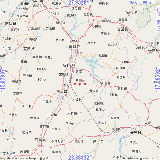
Dongping GPS coordinates[2]
27° 18' 35.352" North, 116° 40' 58.044" East
| Map corner | latitude | longitude |
|---|---|---|
| Upper-left | 27.93281°, | 115.97967° |
| Center: | 27.30982°, | 116.68279° |
| Lower-right: | 26.68332°, | 117.38592° |
| Map W x H: | 138.9×138.9 km | = 86.3×86.3mi |
| max Lat: | 53.31946° ⇑77.4% North |
| Dongping: | 27.30982° |
| min Lat: | ⇓22.6% South 18.22056° |
| min Long | Dongping | max Long |
| 75.07348° | 116.68279° | 134.28917° |
| W 64.2%⇐ | ⇒35.8% E |
Elevation
Elevation of Dongping is 114 m = 374 ft, and this is 370.8 m = 1217 ft below average elevation for this country.
| Max E: |
5622 m = 18445 ft | 57.5% |
| Avg. | 484.8 m = 1591 ft | |
| Dongping | 114 m = 374 ft | |
Min E: |
-3 m = -10 ft | 42.5% |
See also: China elevation on elevation.city.
Geographical zone
Dongping is located in North temperate zone (between Tropic of Cancer and the Arctic Circle). Distance of this Northern Tropic circle is 430.6 km =267.6 mi to South.| Distance of | km | miles | from Dongping |
|---|---|---|---|
| North Pole | 6970.5 | 4331.3 | to North |
| Arctic Circle | 4364.6 | 2712 | to North |
| Tropic Cancer | 430.6 | 267.6 | to South |
| Equator | 3036.6 | 1886.9 | to South |


Nearby cities:
15 places around Dongping: (largest is in red/bold)
• Hongmen
20.4 km =12.7 mi,  7°
7°
• Jianchang
28 km =17.4 mi,  351°
351°
• Laixi
15.2 km =9.4 mi,  223°
223°
• Lita
15.5 km =9.6 mi,  290°
290°
• Long’an
15 km =9.3 mi,  127°
127°
• Qiawan
11.4 km =7.1 mi,  249°
249°
• Qincheng
18.6 km =11.6 mi,  234°
234°
• Rifeng
22.6 km =14 mi,  93°
93°
• Sangtian
23.5 km =14.6 mi,  209°
209°
• Shangtang
8.3 km =5.2 mi,  339°
339°
• Shishan
21.4 km =13.3 mi,  239°
239°
• Tanxi
25.3 km =15.7 mi,  95°
95°
• Tianjingyuan
24.9 km =15.5 mi, 351°
• Xinfengjie
15.9 km =9.9 mi,  324°
324°
• Zhuliang
19.4 km =12.1 mi, 335°
Sources, notices
• [Note1] Compared only with cities in China existing in our database
• [Src1] Map data: © OpenStreetMap contributors (CC-BY-SA)
• [Src2] Other city data from geonames.org with taken over terms of usage.
• [Src3] Geographical zone / Annual Mean Temperature by Robert A. Rohde @ Wikipedia
