Dajipu geodata
Dajipu (Hubei) is a seat of a fourth-order administrative division; located in China in Asia/Shanghai (GMT+8) time zone. In our database, there are 1268 cities with bigger population. Compared to other cities in China, 53.5% of cities are located further ↑North; 54.4% of cities are located further ←West and 71.6% of cities have higher elevation than Dajipu. Note1


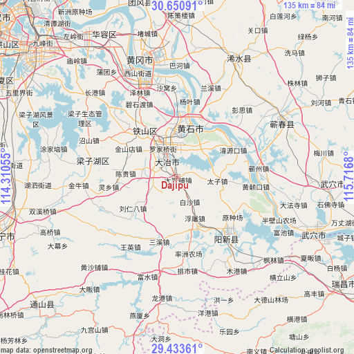
Dajipu GPS coordinates[2]
30° 2' 38.868" North, 115° 0' 49.212" East
| Map corner | latitude | longitude |
|---|---|---|
| Upper-left | 30.65091°, | 114.31055° |
| Center: | 30.04413°, | 115.01367° |
| Lower-right: | 29.43361°, | 115.7168° |
| Map W x H: | 135.4×135.4 km | = 84.1×84.1mi |
| max Lat: | 53.31946° ⇑53.5% North |
| Dajipu: | 30.04413° |
| min Lat: | ⇓46.5% South 18.22056° |
| min Long | Dajipu | max Long |
| 75.07348° | 115.01367° | 134.28917° |
| W 54.4%⇐ | ⇒45.6% E |
Elevation
Elevation of Dajipu is 46 m = 151 ft, and this is 438.8 m = 1440 ft below average elevation for this country.
| Max E: |
5622 m = 18445 ft | 71.6% |
| Avg. | 484.8 m = 1591 ft | |
| Dajipu | 46 m = 151 ft | |
Min E: |
-3 m = -10 ft | 28.4% |
See also: China elevation on elevation.city.
Geographical zone
Dajipu is located in North temperate zone (between Tropic of Cancer and the Arctic Circle). Distance of this Northern Tropic circle is 734.7 km =456.5 mi to South.| Distance of | km | miles | from Dajipu |
|---|---|---|---|
| North Pole | 6666.5 | 4142.4 | to North |
| Arctic Circle | 4060.6 | 2523.1 | to North |
| Tropic Cancer | 734.7 | 456.5 | to South |
| Equator | 3340.6 | 2075.8 | to South |


Nearby cities:
15 places around Dajipu: (largest is in red/bold)
• Baisha
10.6 km =6.6 mi,  152°
152°
• Chengui
20.6 km =12.8 mi,  271°
271°
• Dawang
10.1 km =6.3 mi,  93°
93°
• Daye
7.5 km =4.7 mi,  305°
305°
• Dengyue
16.2 km =10.1 mi,  12°
12°
• Dongfenglu
7.2 km =4.5 mi,  318°
318°
• Futu
16.8 km =10.4 mi,  156°
156°
• Jinshandian
18.1 km =11.2 mi, 307°
• Laoxialu
16.3 km =10.1 mi,  346°
346°
• Luoqiao
12.8 km =8 mi,  333°
333°
• Majiao
8.4 km =5.2 mi,  284°
284°
• Taizi
16.4 km =10.2 mi, 94°
• Tuanchengshan
17.6 km =10.9 mi,  4°
4°
• Wangren
16.1 km =10 mi,  40°
40°
• Yinzu
15.4 km =9.6 mi,  232°
232°
Sources, notices
• [Note1] Compared only with cities in China existing in our database
• [Src1] Map data: © OpenStreetMap contributors (CC-BY-SA)
• [Src2] Other city data from geonames.org with taken over terms of usage.
• [Src3] Geographical zone / Annual Mean Temperature by Robert A. Rohde @ Wikipedia
