Xinghai geodata
Xinghai (Liaoning) is a seat of a fourth-order administrative division; located in China in Asia/Shanghai (GMT+8) time zone. In our database, there are 1268 cities with bigger population. Compared to other cities in China, 88.9% of cities are located further ↓South; 92.4% of cities are located further ←West and 79.8% of cities have higher elevation than Xinghai. Note1


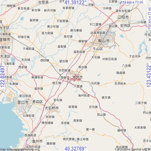
Xinghai GPS coordinates[2]
40° 51' 41.724" North, 122° 43' 41.124" East
| Map corner | latitude | longitude |
|---|---|---|
| Upper-left | 41.39122°, | 122.02497° |
| Center: | 40.86159°, | 122.72809° |
| Lower-right: | 40.32769°, | 123.43122° |
| Map W x H: | 118.3×118.3 km | = 73.5×73.5mi |
| max Lat: | 53.31946° ⇑11.1% North |
| Xinghai: | 40.86159° |
| min Lat: | ⇓88.9% South 18.22056° |
| min Long | Xinghai | max Long |
| 75.07348° | 122.72809° | 134.28917° |
| W 92.4%⇐ | ⇒7.6% E |
Elevation
Elevation of Xinghai is 27 m = 89 ft, and this is 457.8 m = 1502 ft below average elevation for this country.
| Max E: |
5622 m = 18445 ft | 79.8% |
| Avg. | 484.8 m = 1591 ft | |
| Xinghai | 27 m = 89 ft | |
Min E: |
-3 m = -10 ft | 20.2% |
See also: China elevation on elevation.city.
Geographical zone
Xinghai is located in North temperate zone (between Tropic of Cancer and the Arctic Circle). Distance of this Northern Tropic circle is 1937.5 km =1203.9 mi to South.| Distance of | km | miles | from Xinghai |
|---|---|---|---|
| North Pole | 5463.7 | 3395 | to North |
| Arctic Circle | 2857.8 | 1775.8 | to North |
| Tropic Cancer | 1937.5 | 1203.9 | to South |
| Equator | 4543.4 | 2823.1 | to South |


Nearby cities:
15 places around Xinghai: (largest is in red/bold)
• Bali
8.4 km =5.2 mi,  164°
164°
• Dongsi
9.1 km =5.7 mi,  295°
295°
• Ganquan
15.6 km =9.7 mi,  42°
42°
• Ganwang
15.8 km =9.8 mi,  250°
250°
• Gengzhuang
13.9 km =8.6 mi,  350°
350°
• Haicheng
2 km =1.2 mi,  124°
124°
• Haizhou
1.8 km =1.1 mi,  141°
141°
• Maoqi
8.2 km =5.1 mi,  200°
200°
• Nantai
9.5 km =5.9 mi, 42°
• Pailou
16.1 km =10 mi,  152°
152°
• Qianliu
8.2 km =5.1 mi, 254°
• Wangshi
7.4 km =4.6 mi,  91°
91°
• Xiangtang
4.7 km =2.9 mi,  133°
133°
• Xiliu
8.9 km =5.5 mi,  260°
260°
• Zhongxiao
14.7 km =9.1 mi,  282°
282°
Sources, notices
• [Note1] Compared only with cities in China existing in our database
• [Src1] Map data: © OpenStreetMap contributors (CC-BY-SA)
• [Src2] Other city data from geonames.org with taken over terms of usage.
• [Src3] Geographical zone / Annual Mean Temperature by Robert A. Rohde @ Wikipedia
