Ganquan geodata
Ganquan (Liaoning) is a seat of a fourth-order administrative division; located in China in Asia/Shanghai (GMT+8) time zone. In our database, there are 1268 cities with bigger population. Compared to other cities in China, 89.1% of cities are located further ↓South; 92.6% of cities are located further ←West and 69.7% of cities have higher elevation than Ganquan. Note1


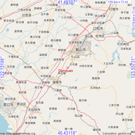
Ganquan GPS coordinates[2]
40° 57' 51.336" North, 122° 51' 15.048" East
| Map corner | latitude | longitude |
|---|---|---|
| Upper-left | 41.49307°, | 122.15106° |
| Center: | 40.96426°, | 122.85418° |
| Lower-right: | 40.43118°, | 123.55731° |
| Map W x H: | 118.1×118.1 km | = 73.4×73.4mi |
| max Lat: | 53.31946° ⇑10.9% North |
| Ganquan: | 40.96426° |
| min Lat: | ⇓89.1% South 18.22056° |
| min Long | Ganquan | max Long |
| 75.07348° | 122.85418° | 134.28917° |
| W 92.6%⇐ | ⇒7.4% E |
Elevation
Elevation of Ganquan is 53 m = 174 ft, and this is 431.8 m = 1417 ft below average elevation for this country.
| Max E: |
5622 m = 18445 ft | 69.7% |
| Avg. | 484.8 m = 1591 ft | |
| Ganquan | 53 m = 174 ft | |
Min E: |
-3 m = -10 ft | 30.3% |
See also: China elevation on elevation.city.
Geographical zone
Ganquan is located in North temperate zone (between Tropic of Cancer and the Arctic Circle). Distance of this Northern Tropic circle is 1948.9 km =1211 mi to South.| Distance of | km | miles | from Ganquan |
|---|---|---|---|
| North Pole | 5452.3 | 3387.9 | to North |
| Arctic Circle | 2846.4 | 1768.7 | to North |
| Tropic Cancer | 1948.9 | 1211 | to South |
| Equator | 4554.8 | 2830.2 | to South |


Nearby cities:
15 places around Ganquan: (largest is in red/bold)
• Anshan
21.1 km =13.1 mi,  32°
32°
• Bali
21.3 km =13.2 mi,  203°
203°
• Datun
5.9 km =3.7 mi,  56°
56°
• Dongsi
20.3 km =12.6 mi,  248°
248°
• Fu’an
12.5 km =7.8 mi,  350°
350°
• Gengzhuang
13 km =8.1 mi,  280°
280°
• Haicheng
15.4 km =9.6 mi,  215°
215°
• Haizhou
16 km =9.9 mi, 216°
• Jiupu
13.9 km =8.6 mi,  35°
35°
• Mafeng
17.9 km =11.1 mi,  164°
164°
• Nantai
6.1 km =3.8 mi, 223°
• Wangshi
12 km =7.5 mi, 195°
• Wangtai
21.2 km =13.2 mi, 276°
• Xiangtang
16.3 km =10.1 mi,  206°
206°
• Xinghai
15.6 km =9.7 mi, 222°
Sources, notices
• [Note1] Compared only with cities in China existing in our database
• [Src1] Map data: © OpenStreetMap contributors (CC-BY-SA)
• [Src2] Other city data from geonames.org with taken over terms of usage.
• [Src3] Geographical zone / Annual Mean Temperature by Robert A. Rohde @ Wikipedia
