Yulin geodata
Yulin (Chongqing) is a seat of a fourth-order administrative division; located in China in Asia/Shanghai (GMT+8) time zone. In our database, there are 1268 cities with bigger population. Compared to other cities in China, 59.4% of cities are located further ↓South; 73.9% of cities are located further →East and 78.5% of cities have lower elevation than Yulin. Note1


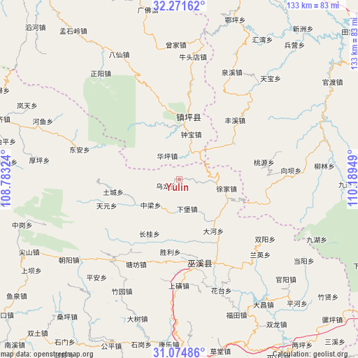
Yulin GPS coordinates[2]
31° 40' 30.612" North, 109° 29' 10.896" East
| Map corner | latitude | longitude |
|---|---|---|
| Upper-left | 32.27162°, | 108.78324° |
| Center: | 31.67517°, | 109.48636° |
| Lower-right: | 31.07486°, | 110.18949° |
| Map W x H: | 133.1×133.1 km | = 82.7×82.7mi |
| max Lat: | 53.31946° ⇑40.6% North |
| Yulin: | 31.67517° |
| min Lat: | ⇓59.4% South 18.22056° |
| min Long | Yulin | max Long |
| 75.07348° | 109.48636° | 134.28917° |
| W 26.1%⇐ | ⇒73.9% E |
Elevation
Elevation of Yulin is 631 m = 2070 ft, and this is 146.2 m = 480 ft above average elevation for this country.
| Max E: |
5622 m = 18445 ft | 21.5% |
| Yulin | 631 m 2070 ft | |
| Avg. | 484.8 m = 1591 ft | |
Min E: |
-3 m = -10 ft | 78.5% |
See also: China elevation on elevation.city.
Geographical zone
Yulin is located in North temperate zone (between Tropic of Cancer and the Arctic Circle). Distance of this Northern Tropic circle is 916 km =569.2 mi to South.| Distance of | km | miles | from Yulin |
|---|---|---|---|
| North Pole | 6485.1 | 4029.7 | to North |
| Arctic Circle | 3879.2 | 2410.4 | to North |
| Tropic Cancer | 916 | 569.2 | to South |
| Equator | 3521.9 | 2188.4 | to South |


Nearby cities:
15 places around Yulin: (largest is in red/bold)
• Bailu
19.1 km =11.9 mi,  111°
111°
• Changgui
23.1 km =14.4 mi,  209°
209°
• Chengxiang
33.4 km =20.8 mi,  157°
157°
• Dadong
22.8 km =14.2 mi,  146°
146°
• Fenghuang
30.5 km =19 mi,  175°
175°
• Fengxi
30.2 km =18.8 mi,  42°
42°
• Ningchang
26 km =16.2 mi, 145°
• Shengli
27.1 km =16.8 mi,  187°
187°
• Tangfang
35.6 km =22.1 mi, 208°
• Taoyuan
32.2 km =20 mi,  77°
77°
• Tianxing
23.3 km =14.5 mi,  167°
167°
• Tucheng
25 km =15.5 mi,  259°
259°
• Wulong
5.7 km =3.5 mi,  246°
246°
• Xujia
17.8 km =11.1 mi,  100°
100°
• Zhongliang
16.9 km =10.5 mi,  235°
235°
Sources, notices
• [Note1] Compared only with cities in China existing in our database
• [Src1] Map data: © OpenStreetMap contributors (CC-BY-SA)
• [Src2] Other city data from geonames.org with taken over terms of usage.
• [Src3] Geographical zone / Annual Mean Temperature by Robert A. Rohde @ Wikipedia
